IMAGES TAKEN NEAR TO
Railway Terrace, SWANSEA, SA9 1PT
Introduction
This page details the photographs taken nearby to Railway Terrace, SA9 1PT by members of the Geograph project.
The Geograph project started in 2005 with the aim of publishing, organising and preserving representative images for every square kilometre of Great Britain, Ireland and the Isle of Man.

There are currently over 7.5m images from over14,400 individuals and you can help contribute to the project by visiting https://www.geograph.org.uk
Image Map
Images are licensed for reuse under creativecommons.org/licenses/by-sa/2.0
Notes
- Clicking on the map will re-center to the selected point.
- The higher the marker number, the further away the image location is from the centre of the postcode.
Image Listing (37 Images Found)
Images are licensed for reuse under creativecommons.org/licenses/by-sa/2.0
Image
Details
Distance
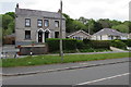
1
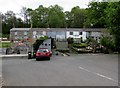
Railway Terrace, Ystradgynlais
Row of houses set back 40 metres from Neath Road in the south of Ystradgynlais.
Viewed in 2016. It has been many years since a railway was nearby.
Image: © Jaggery
Taken: 16 May 2016
0.01 miles
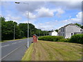
2
Neath Road bus shelter near Ystradgynlais
The brick shelter is on the side of the road for buses towards Neath.
The grey back of the Ystradgynlais boundary sign http://www.geograph.org.uk/photo/5076590 is on the right.
Image: © Jaggery
Taken: 16 May 2016
0.03 miles
3
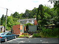
Railway Terrace
The railway is no more but these cottages still indicate the Swansea Valley Line that is no more.
Image: © Jonathan Billinger
Taken: 8 Aug 2008
0.04 miles
4
Road to Ystradgynlais
Here the road is aligned along the track bed of the former Swansea Vale and Neath and Brecon Junction Railway south of the town.
Image: © Jonathan Billinger
Taken: 8 Aug 2008
0.04 miles
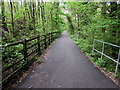
5
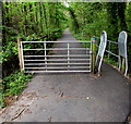
Gate and barrier across National Cycle Network Route 43, Ystradgynlais
Preventing vehicular misuse of this https://www.geograph.org.uk/photo/6132343 footpath/cycleway on the route of a dismantled railway, part of National Cycle Network Route 43 which when complete will extend from Builth Wells to Swansea. Walkers and cyclists can go through the inwardly-sloping barrier on the right.
Image: © Jaggery
Taken: 16 May 2016
0.04 miles
6
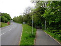
Cycle Route 43 diverging from Neath Road, Ystradgynlais
Part of National Cycle Network Route 43, the cycleway/footpath on the right uses the route of a dismantled railway. When complete, Route 43 will extend from Builth Wells to Swansea.
Image: © Jaggery
Taken: 16 May 2016
0.05 miles
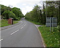
7
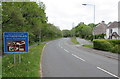
Ystradgynlais boundary sign
Facing Neath Road at the southern edge of Ystradgynlais in SW Powys. Ystradgynlais is the second largest town in Powys, after Newtown. Their populations on the day of the 2011 Census were 8,092 and 11,357 respectively.
Image: © Jaggery
Taken: 16 May 2016
0.05 miles
8
Railway Cottage, Neath Road, Ystradgynlais
Railway Terrace and Station Road are nearby, as is this https://www.geograph.org.uk/photo/6132343 footpath/cycleway on the route of a dismantled railway. Passenger services at Ystradgynlais station ended in 1932 though the line through the station remained open for freight trains for some time thereafter.
Image: © Jaggery
Taken: 16 May 2016
0.05 miles
9
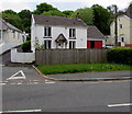
Housing variety in Ystradgynlais
On the east side of Neath Road in the south of Ystradgynlais.
Image: © Jaggery
Taken: 16 May 2016
0.06 miles
10
Footpath/cycleway on the route of a dismantled railway, Ystradgynlais
Part of National Cycle Network Route 43 which when complete will extend from Builth Wells to Swansea.
Image: © Jaggery
Taken: 16 May 2016
0.06 miles