1
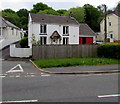
Housing variety in Ystradgynlais
On the east side of Neath Road in the south of Ystradgynlais.
Image: © Jaggery
Taken: 16 May 2016
0.01 miles
2
Bilingual name sign, Neath Road, Ystradgynlais
The sign on the left here https://www.geograph.org.uk/photo/6132323 shows that Neath Road is Heol Castellnedd in Welsh.
Image: © Jaggery
Taken: 16 May 2016
0.01 miles
3
Road to Ystradgynlais
Here the road is aligned along the track bed of the former Swansea Vale and Neath and Brecon Junction Railway south of the town.
Image: © Jonathan Billinger
Taken: 8 Aug 2008
0.03 miles
4
Railway Cottage, Neath Road, Ystradgynlais
Railway Terrace and Station Road are nearby, as is this https://www.geograph.org.uk/photo/6132343 footpath/cycleway on the route of a dismantled railway. Passenger services at Ystradgynlais station ended in 1932 though the line through the station remained open for freight trains for some time thereafter.
Image: © Jaggery
Taken: 16 May 2016
0.03 miles
5
Ystradgynlais boundary sign
Facing Neath Road at the southern edge of Ystradgynlais in SW Powys. Ystradgynlais is the second largest town in Powys, after Newtown. Their populations on the day of the 2011 Census were 8,092 and 11,357 respectively.
Image: © Jaggery
Taken: 16 May 2016
0.05 miles
6
Cycle Route 43 diverging from Neath Road, Ystradgynlais
Part of National Cycle Network Route 43, the cycleway/footpath on the right uses the route of a dismantled railway. When complete, Route 43 will extend from Builth Wells to Swansea.
Image: © Jaggery
Taken: 16 May 2016
0.05 miles
7
Neath Road bus shelter near Ystradgynlais
The brick shelter is on the side of the road for buses towards Neath.
The grey back of the Ystradgynlais boundary sign http://www.geograph.org.uk/photo/5076590 is on the right.
Image: © Jaggery
Taken: 16 May 2016
0.05 miles
8
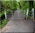
Gate and barrier across National Cycle Network Route 43, Ystradgynlais
Preventing vehicular misuse of this https://www.geograph.org.uk/photo/6132343 footpath/cycleway on the route of a dismantled railway, part of National Cycle Network Route 43 which when complete will extend from Builth Wells to Swansea. Walkers and cyclists can go through the inwardly-sloping barrier on the right.
Image: © Jaggery
Taken: 16 May 2016
0.05 miles
9
Mini-roundabout, Neath Road, Ystradgynlais
At the southern edge of Ystradgynlais, the second-largest town (ranked by population) in Powys, after Newtown.
Image: © Jaggery
Taken: 16 May 2016
0.06 miles
10
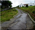
Inglewood access road, Ystradgynlais
Ascending from the east side of Neath Road in the south of Ystradgynlais.
Image: © Jaggery
Taken: 16 May 2016
0.06 miles


