1
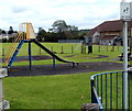
Children's play area, Abercrave
A view looking towards the Miners' Welfare Hall. http://www.geograph.org.uk/photo/3151206
Image: © Jaggery
Taken: 29 Aug 2011
0.01 miles
2
Miners' Welfare Hall, Abercrave
The building opened in 1937 as a Miners' Welfare Hall. It is currently used for social occasions such as senior citizens' meetings, WI meetings and discos. Concerts are held here occasionally.
Image: © Jaggery
Taken: 29 Aug 2011
0.02 miles
3
Rotafix Abercrave
Rotafix House, Hennoyadd Road, is the headquarters of Rotafix, manufacturers of resinwood construction and structural adhesives, grouts, cements and coatings.
Image: © Jaggery
Taken: 29 Aug 2011
0.05 miles
4
Southern end of Hennoyadd Road, Abercrave
Viewed from Heol Tawe. All references I've consulted show the street as Hennoyadd Road whereas the name sign by the wall shows only Hennoyadd.
Hennoyadd is an Anglicised form of the Welsh Henneuadd which is the name of a nearby street.
Image: © Jaggery
Taken: 29 Aug 2011
0.05 miles
5
Barn Cottages, Abercrave
A row of three low-roofed houses in Hennoyadd, Abercrave.
Image: © Jaggery
Taken: 29 Aug 2011
0.06 miles
6
School gates, Abercrave
This is the School Road entrance to Abercrave Primary School.
The grey tower in the right background is part of the nearby fire station. http://www.geograph.org.uk/photo/3149509
Image: © Jaggery
Taken: 29 Aug 2011
0.06 miles
7
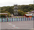
Fire tower and a colourful fence, Abercrave
The training and drill tower in behind the local fire station, http://www.geograph.org.uk/photo/3149509 out of shot on the right.
Viewed from School Road looking across the Abercrave Primary School site.
Image: © Jaggery
Taken: 29 Aug 2011
0.06 miles
8
Hen Neuadd
Adeiladwyd y ty cyntaf yn ystod y 15g ac fe'i hailgodwyd yn bennaf yn ystod y 17g. Gweddnewidiwyd yr anhedd-dy yn y 19g ac fe'i hadnewidiwyd yn 1986.
With early C15 origins the house was largely rebuilt during the 17th century. Altered during the 19th century the property was restored in 1986.
Image: © Alan Richards
Taken: 20 Jul 2020
0.06 miles
9
Henneuadd, Abercrave
Houses at the eastern end of the residential street named Henneuadd.
Image: © Jaggery
Taken: 29 Aug 2011
0.06 miles
10
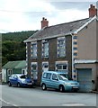
Blues and greens, Abercrave
The blue cars match the blue theme of the house and garage. The green corrugated building has a green forested backdrop. The location is the corner of Hennoyadd Road and Heol Tawe.
Alan Jones has informed me that the green shed was an award-winning fish and chip shop run by the Parsons family who lived in the attached house.
Image: © Jaggery
Taken: 29 Aug 2011
0.07 miles


