IMAGES TAKEN NEAR TO
Ffordd Cefnllan, SWANSEA, SA8 4NY
Introduction
This page details the photographs taken nearby to Ffordd Cefnllan, SA8 4NY by members of the Geograph project.
The Geograph project started in 2005 with the aim of publishing, organising and preserving representative images for every square kilometre of Great Britain, Ireland and the Isle of Man.

There are currently over 7.5m images from over14,400 individuals and you can help contribute to the project by visiting https://www.geograph.org.uk
Image Map (Loading...)


Getting Data...Please wait
Leaflet Map data © OpenStreetMap
Images are licensed for reuse under creativecommons.org/licenses/by-sa/2.0
Notes
- Clicking on the map will re-center to the selected point.
- The higher the marker number, the further away the image location is from the centre of the postcode.
Image Listing (11 Images Found)
Images are licensed for reuse under creativecommons.org/licenses/by-sa/2.0
Image
Details
Distance
1
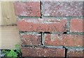
Ordnance Survey Rivet
This OS rivet can be found on the wall of No40 Gelligron Road. It marks a point 99.703m above mean sea level.
Image: © Adrian Dust
Taken: 14 Apr 2020
0.04 miles
2
Ordnance Survey Cut Mark
This OS pivot can be found on No26 Cefnllan Road. It marks a point 110.722m above mean sea level.
Image: © Adrian Dust
Taken: 14 Apr 2020
0.08 miles
3
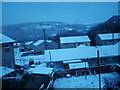
Alltycham
This is the view from my house in Pontardawe during the snowy days of November 2005.
Image: © Aaron Jones
Taken: 25 Nov 2005
0.10 miles
4
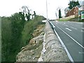
Reinforced A474 north from Pontardawe
As the road climbs north, the houses on the left side give way to the gorge of the Upper Clydach river in Cwm Du Glen.
For many months the road had been reduced to a single lane because the outside was falling into the gorge. Now drivers have a newly surfaced road and a tall stone wall that hides the huge drop-off on the other side. Even pedestrians cannot see over - this shot was taken by climbing the crash barrier.
Image: © Nigel Davies
Taken: 26 Apr 2008
0.14 miles
5
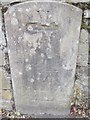
Ordnance Survey Cut Mark
This OS Cut Mark can be found to the SW of the road. It was once on the NE side and part buried. Now moved after road works. It did mark a point 96.1400m above mean sea level. The Stone has VI & Hamlet of Mawr ? carved into it. On the 1877 map it is shown as a Mile Stone - Neath 6. The word Neath has been removed from below the VI.
Image: © Adrian Dust
Taken: 18 Jun 2013
0.15 miles
6
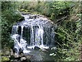
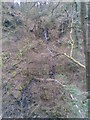
Waterfall on the Upper Clydach river
This waterfall is both the largest and the furthest upstream on the maintained path in the Cwm Du Glen reserve.
Image: © Nigel Davies
Taken: 26 Apr 2008
0.17 miles
7
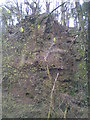
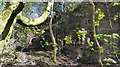
Pontardawe Gorge
Pontardawe Gorge rock formation (Pontardawe Gorge Walk).
Image: © Tawe Tours
Taken: Unknown
0.17 miles

9
Pontardawe Gorge Waterfall
Pontardawe Gorge Waterfall flowing into river (Pontardawe Gorge Walk).
Image: © Tawe Tours
Taken: Unknown
0.19 miles