IMAGES TAKEN NEAR TO
Gorsewood Drive, MILFORD HAVEN, SA73 3EP
Introduction
This page details the photographs taken nearby to Gorsewood Drive, SA73 3EP by members of the Geograph project.
The Geograph project started in 2005 with the aim of publishing, organising and preserving representative images for every square kilometre of Great Britain, Ireland and the Isle of Man.

There are currently over 7.5m images from over14,400 individuals and you can help contribute to the project by visiting https://www.geograph.org.uk
Image Map (Loading...)


Getting Data...Please wait
Leaflet Map data © OpenStreetMap
Images are licensed for reuse under creativecommons.org/licenses/by-sa/2.0
Notes
- Clicking on the map will re-center to the selected point.
- The higher the marker number, the further away the image location is from the centre of the postcode.
Image Listing (37 Images Found)
Images are licensed for reuse under creativecommons.org/licenses/by-sa/2.0
Image
Details
Distance
1
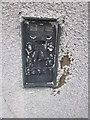
Ordnance Survey Flush Bracket (G4977)
This OS Flush Bracket (Tide Gauge Aux 1) can be found on the SW face of the Port Authority building. It marks a point 31.730m above mean sea level.
Image: © Adrian Dust
Taken: 8 Nov 2015
0.09 miles
2
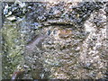
Ordnance Survey Cut Mark
Little can be seen of this OS cut mark. lime has built up over most of it. It can be found to the right of the entrance into Fort Hubberston. It marked a point 38.070m above mean sea level.
Image: © Adrian Dust
Taken: 8 Nov 2015
0.10 miles
3
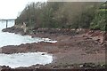
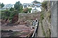
Conduit Beach, Hakin
Beach accessible only by footpaths and private slipway.
Image: © M J Roscoe
Taken: 23 Oct 2023
0.11 miles
4
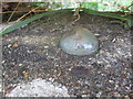
Ordnance Survey Tide Gauge Bench Mark (Bolt)
This OS Bolt can be found on the low wall to the west of the Jetty. It marks a point 13.024m above mean sea level.
Image: © Adrian Dust
Taken: 8 Nov 2015
0.11 miles
5

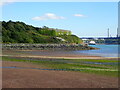
Milford Haven towards St Anne's Head
The Port Authority jetty and Offices in the foreground. Murco Refinery jetty on the left, the 'Isle of Innesfree' ferry inbound, then to the right is the new LNG jetty for the South Hook LNG facility.
Image: © Shaun Butler
Taken: 8 Oct 2008
0.15 miles
6
Path on sea wall at The Breakwater, Hakin
Public footpath on ledge on sea/retaining wall - the continuation of the path in Image At the slight angle in the wall there are steps down to Conduit Beach. Walkers can then cross the outflow from the culverts to a path, at the end of the wall, up to Conduit Lane.
Image: © M J Roscoe
Taken: 23 Oct 2023
0.15 miles
7
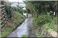
Conduit Lane, Hakin
A public footpath towards Conduit Beach runs down the road past Conduit Lodge, left.
Image: © M J Roscoe
Taken: 23 Oct 2023
0.16 miles
8

Path on ledge of retaining wall, Hakin
The public footpath leads to steep steps up to a path junction on top of the cliff. Note the metal platform at the buttress! For view of path from top of steps - Image
Image: © M J Roscoe
Taken: 23 Oct 2023
0.18 miles
9
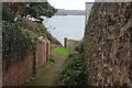
End of footpath to cliff top
Public footpath from St Anne's Drive to waterside path - down steps Image to the right or along the cliff top to left.
Image: © M J Roscoe
Taken: 23 Oct 2023
0.19 miles
10
Hubberstone Fort
Built to defend Pembroke Royal Naval dockyard in the 1850's together with Popton Fort on the other side of the estuary. https://en.wikipedia.org/wiki/Fort_Hubberstone
Image: © Eirian Evans
Taken: 30 Aug 2022
0.19 miles