IMAGES TAKEN NEAR TO
St. Marys Road, PEMBROKE DOCK, SA72 6HU
Introduction
This page details the photographs taken nearby to St. Marys Road, SA72 6HU by members of the Geograph project.
The Geograph project started in 2005 with the aim of publishing, organising and preserving representative images for every square kilometre of Great Britain, Ireland and the Isle of Man.

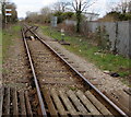
There are currently over 7.5m images from over14,400 individuals and you can help contribute to the project by visiting https://www.geograph.org.uk
Image Map (Loading...)


Getting Data...Please wait
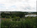
Leaflet Map data © OpenStreetMap
Images are licensed for reuse under creativecommons.org/licenses/by-sa/2.0
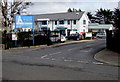
Notes
- Clicking on the map will re-center to the selected point.
- The higher the marker number, the further away the image location is from the centre of the postcode.
Image Listing (89 Images Found)
Images are licensed for reuse under creativecommons.org/licenses/by-sa/2.0
Image
Details
Distance
1
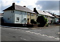
Trinity Road houses, Pembroke Dock
On the east side of Trinity Road, viewed across Hawkstone Road.
Image: © Jaggery
Taken: 13 Mar 2015
0.03 miles
2
Towards St John's Road, Pembroke Dock
From Hawkstone Road.
Image: © Jaggery
Taken: 13 Mar 2015
0.06 miles
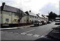
3

Hawkstone Road houses, Pembroke Dock
Viewed from the corner of Trinity Road.
Image: © Jaggery
Taken: 13 Mar 2015
0.07 miles
4
Cromwell Street, Pembroke Dock
100 metre long dead end street on the south side of Hawkstone Road.
Image: © Jaggery
Taken: 13 Mar 2015
0.09 miles
5
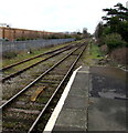
Towards Pembroke from Pembroke Dock by rail
Looking east from the terminus station at Pembroke Dock.
Scheduled journey time to Pembroke station http://www.geograph.org.uk/photo/3650784 is 8 minutes.
The route includes a 400 metres long tunnel.
Image: © Jaggery
Taken: 13 Mar 2015
0.10 miles
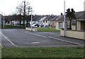
6
Towards Pembroke Dock station from Llanion Crossing
Viewed from this http://www.geograph.org.uk/photo/4394917 level crossing.
The end of the line http://www.geograph.org.uk/photo/4383275 at Pembroke Dock station is 600 metres ahead.
Image: © Jaggery
Taken: 13 Mar 2015
0.10 miles
7

Jumping Beans, Pembroke Dock
Hawkstone Road day nursery, opposite Cromwell Street.
Image: © Jaggery
Taken: 13 Mar 2015
0.11 miles
8
View across the eastern part of Pembroke Dock
In the foreground is a school (not marked on the map) and its playing fields. The houses on the left are in the suburb of Llanion and between there and the A477 (again more than is marked on the current map).
The hill just visible on the horizon in the centre is Foel Cwmcerwyn.
Image: © Colin Bell
Taken: 16 Jun 2008
0.11 miles
9

Jumping Beans day nursery and car, Pembroke Dock
Viewed from Hawkstone Road. The nursery http://www.geograph.org.uk/photo/4383873 is opposite Cromwell Street.
Image: © Jaggery
Taken: 13 Mar 2015
0.12 miles
10
Argyle Medical Group, Pembroke Dock
Entrance from Argyle Street.
Image: © Jaggery
Taken: 13 Mar 2015
0.13 miles