IMAGES TAKEN NEAR TO
Bevelin Hall, SAUNDERSFOOT, SA69 9PG
Introduction
This page details the photographs taken nearby to Bevelin Hall, SA69 9PG by members of the Geograph project.
The Geograph project started in 2005 with the aim of publishing, organising and preserving representative images for every square kilometre of Great Britain, Ireland and the Isle of Man.

There are currently over 7.5m images from over14,400 individuals and you can help contribute to the project by visiting https://www.geograph.org.uk
Image Map
Images are licensed for reuse under creativecommons.org/licenses/by-sa/2.0
Notes
- Clicking on the map will re-center to the selected point.
- The higher the marker number, the further away the image location is from the centre of the postcode.
Image Listing (23 Images Found)
Images are licensed for reuse under creativecommons.org/licenses/by-sa/2.0
Image
Details
Distance
1
Stammers Lane, Saundersfoot
Stammers Lane ascends from the B4316 in the south of Saundersfoot.
Image: © Jaggery
Taken: 16 Jul 2016
0.14 miles
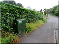
2
Telecoms equipment on a south Saundersfoot corner
A telecoms cabinet and a BT phonebox are on the corner of the B4316 and Stammers Lane. http://www.geograph.org.uk/photo/5168004
Image: © Jaggery
Taken: 16 Jul 2016
0.17 miles
3
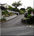
Sandy Hill Road, Saundersfoot
Ascending from the B4316.
Image: © Jaggery
Taken: 16 Jul 2016
0.17 miles
4
Fibre broadband telecoms cabinet, Saundersfoot
Alongside the B4316 opposite the Stammers Lane junction.
A label on the cabinet shows 'Fibre Broadband is here' and its Welsh equivalent.
Image: © Jaggery
Taken: 16 Jul 2016
0.17 miles
5
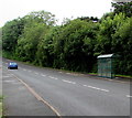
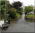
Broadfield Hill bus stop and shelter, Saundersfoot
This bus stop alongside the B4316 Broadfield Hill is for buses to the centre of Saundersfoot.
Image: © Jaggery
Taken: 16 Jul 2016
0.17 miles
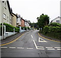
6
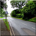
Combined speed limit and speed camera sign, Saundersfoot
Alongside the B4316 in the south of Saundersfoot.
Image: © Jaggery
Taken: 16 Jul 2016
0.18 miles
7
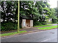
Bus shelter near Cwm Gwennol, Saundersfoot
Alongside the B4316 near the Cwm Gwennol junction http://www.geograph.org.uk/photo/5167984 in the south of Saundersfoot.
This side of the road for buses to Tenby.
Image: © Jaggery
Taken: 16 Jul 2016
0.18 miles
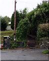
8
Bevelin Lane, Saundersfoot
From the B4316 Bevelin Lane ascends towards Scandinavia Heights.
Image: © Jaggery
Taken: 16 Jul 2016
0.18 miles
9
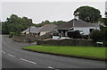
Rushy Lake bungalows, Saundersfoot
Viewed across the B4316 Broadfield Hill.
Image: © Jaggery
Taken: 16 Jul 2016
0.18 miles