IMAGES TAKEN NEAR TO
Heron Way, SWANSEA, SA6 8PS
Introduction
This page details the photographs taken nearby to Heron Way, SA6 8PS by members of the Geograph project.
The Geograph project started in 2005 with the aim of publishing, organising and preserving representative images for every square kilometre of Great Britain, Ireland and the Isle of Man.

There are currently over 7.5m images from over14,400 individuals and you can help contribute to the project by visiting https://www.geograph.org.uk
Image Map (Loading...)


Getting Data...Please wait
Leaflet Map data © OpenStreetMap
Images are licensed for reuse under creativecommons.org/licenses/by-sa/2.0
Notes
- Clicking on the map will re-center to the selected point.
- The higher the marker number, the further away the image location is from the centre of the postcode.
Image Listing (7 Images Found)
Images are licensed for reuse under creativecommons.org/licenses/by-sa/2.0
Image
Details
Distance
1
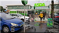
Swansea : ASDA
The city's ASDA store on Heron Way.
Image: © Lewis Clarke
Taken: 15 Jul 2017
0.13 miles
2
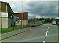
St David's Industrial Estate Access Road 2
Image: © Alex McGregor
Taken: 8 Jun 2011
0.18 miles
3

Sign replacement
This sign was lost in translation last year when an English only speaker misinterpreted the email sent back to them by the Welsh language translator... as the translation.
The sign spent the best part of a year as two posts having been almost instantly removed after the error was realised and now has the correct translation.
The original "translation" back to English read: "I am not in the office at the moment. Send any work to be translated."
Original image can be seen at: http://news.bbc.co.uk/1/hi/wales/7702913.stm
Image: © Hywel Williams
Taken: 19 May 2009
0.21 miles
5
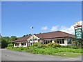
The Dylan Thomas restaurant
Part of the Hungry Horse chain
Image: © David Smith
Taken: 2 Jun 2018
0.21 miles
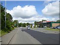
7
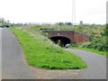
Cycle route 43 passes under the A48
The riverride cycle route is following the path of a dismantled railway through Swansea Vale. At this point there used to be a station or halt for the demolished tin plate works.
Image: © Nigel Davies
Taken: 5 Sep 2009
0.24 miles