IMAGES TAKEN NEAR TO
Hill Lane, KILGETTY, SA68 0QT
Introduction
This page details the photographs taken nearby to Hill Lane, SA68 0QT by members of the Geograph project.
The Geograph project started in 2005 with the aim of publishing, organising and preserving representative images for every square kilometre of Great Britain, Ireland and the Isle of Man.

There are currently over 7.5m images from over14,400 individuals and you can help contribute to the project by visiting https://www.geograph.org.uk
Image Map
Images are licensed for reuse under creativecommons.org/licenses/by-sa/2.0
Notes
- Clicking on the map will re-center to the selected point.
- The higher the marker number, the further away the image location is from the centre of the postcode.
Image Listing (49 Images Found)
Images are licensed for reuse under creativecommons.org/licenses/by-sa/2.0
Image
Details
Distance
1
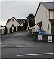
Entrance to Hillcroft Caravan Park, Pentlepoir
Hillcroft is a Caravan and Motorhome Club site on the south side of the A478.
Image: © Jaggery
Taken: 6 Jan 2018
0.00 miles
2
CCTV cameras near a bus shelter, Pentlepoir
Alongside the A478.
Image: © Jaggery
Taken: 6 Jan 2018
0.02 miles
3
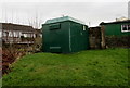
Hill Rise electricity substation, Pentlepoir
Located on the right here, https://www.geograph.org.uk/photo/5646502 the green cabinet is a Western Power Distribution electricity substation.
Image: © Jaggery
Taken: 6 Jan 2018
0.03 miles
4
Queen Elizabeth II postbox near the Pentlepoir boundary sign
Viewed across the A478 from the corner of Hill Rise.
Image: © Jaggery
Taken: 6 Jan 2018
0.03 miles
5
Wooden bench, Hill Rise, Pentlepoir
Near the eastern end of Hill Rise. The A478 junction is behind the camera.
Image: © Jaggery
Taken: 6 Jan 2018
0.04 miles
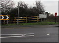
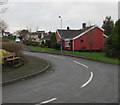
6
Junction of Hill Rise and the A478, Pentlepoir
Near the Pentlepoir boundary sign, Hill Rise from the right joins the A478.
Image: © Jaggery
Taken: 6 Jan 2018
0.04 miles
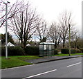
7
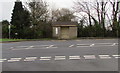
Bus stop and shelter opposite Hill Rise, Pentlepoir
This stop on the east side of the A478 is for buses to Tenby.
Image: © Jaggery
Taken: 6 Jan 2018
0.05 miles
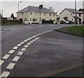
8
Bend in Hill Rise, Pentlepoir
Hill Rise is a cul-de-sac on the north side of the A478.
Image: © Jaggery
Taken: 6 Jan 2018
0.05 miles
9
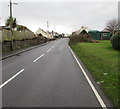
Up the A478, Pentlepoir
The A478 ascends towards the centre of the village. The grassy bank is at the edge of Hill Rise.
Image: © Jaggery
Taken: 6 Jan 2018
0.06 miles
10
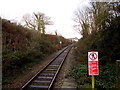
Railway north of Saundersfoot station
Next station ahead is Kilgetty on the route to Carmarthen and Swansea.
Image: © Jaggery
Taken: 6 Jan 2018
0.08 miles