IMAGES TAKEN NEAR TO
The Lone, SWANSEA, SA6 5SX
Introduction
This page details the photographs taken nearby to The Lone, SA6 5SX by members of the Geograph project.
The Geograph project started in 2005 with the aim of publishing, organising and preserving representative images for every square kilometre of Great Britain, Ireland and the Isle of Man.

There are currently over 7.5m images from over14,400 individuals and you can help contribute to the project by visiting https://www.geograph.org.uk
Image Map
Images are licensed for reuse under creativecommons.org/licenses/by-sa/2.0
Notes
- Clicking on the map will re-center to the selected point.
- The higher the marker number, the further away the image location is from the centre of the postcode.
Image Listing (6 Images Found)
Images are licensed for reuse under creativecommons.org/licenses/by-sa/2.0
Image
Details
Distance
1
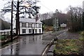
Tafarn y New Inn
Tafarn y New Inn a saif rhwng cyn pentre glofaol Craig Cefn Parc a thre Clydach.
The New Inn public house located between the former mining village of Craig Cefn Parc and the larger settlement of Clydach.
Image: © Alan Richards
Taken: 26 Jan 2014
0.05 miles
3
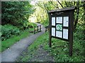
Information board in Cwm Clydach Nature Reserve
The tree lined valley surrounding a crescent shaped portion of the Clydach river is designated as an RSPB Nature Reserve.
This information board is near the car park at the south end.
The trail and public footpath follow the river most of the way up to the next road bridge at Pont Llechart.
Image: © Nigel Davies
Taken: 29 May 2006
0.18 miles
4
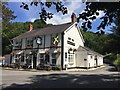
Llwybr i Gwm Clydach / Path to Cwm Clydach
Llwybr cyhoeddus yn mynd i gyfeiriad Tafarn y New Inn yng Nghwm Clydach.
A public footpath heading towards the New Inn public house in Cwm Clydach.
Image: © Alan Richards
Taken: 31 Dec 2019
0.22 miles
5
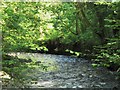
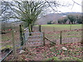
Bend in the River Clydach
This is the view southeast down the river. Although it is now a nature reserve and quite overgrown, there are numerous small signs of mining industry here: building foundations, buried steel ropes and the stone walled artificial bank of the river, visible on the curve in the distance.
Image: © Nigel Davies
Taken: 29 May 2006
0.23 miles
6
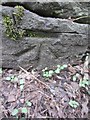
Ordnance Survey Cut Mark
This OS cut mark can be found on the wall to the south of the road. It marks a point 77.053m above mean sea level.
Image: © Adrian Dust
Taken: 17 Mar 2014
0.25 miles