IMAGES TAKEN NEAR TO
Dwrbach, FISHGUARD, SA65 9RN
Introduction
This page details the photographs taken nearby to SA65 9RN by members of the Geograph project.
The Geograph project started in 2005 with the aim of publishing, organising and preserving representative images for every square kilometre of Great Britain, Ireland and the Isle of Man.

There are currently over 7.5m images from over14,400 individuals and you can help contribute to the project by visiting https://www.geograph.org.uk
Image Map (Loading...)


Getting Data...Please wait
Leaflet Map data © OpenStreetMap
Images are licensed for reuse under creativecommons.org/licenses/by-sa/2.0
Notes
- Clicking on the map will re-center to the selected point.
- The higher the marker number, the further away the image location is from the centre of the postcode.
Image Listing (18 Images Found)
Images are licensed for reuse under creativecommons.org/licenses/by-sa/2.0
Image
Details
Distance
1
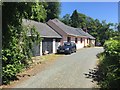
Tredafydd Farm
Tredafydd Farm, near Scleddau.
Image: © Alan Hughes
Taken: 27 Jun 2018
0.01 miles
2
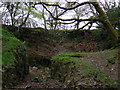
Old quarry, Dwrbach
A cavity scooped out of the valley side for the purpose of excavating stone, presumably some of which must have gone to shore up the causeway across the marsh below.
Image: © Natasha Ceridwen de Chroustchoff
Taken: 28 Apr 2010
0.01 miles
3
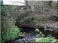
Ancient bridge over the Cleddau
Easily missed tiny arch constructed of huge stones. It carried what was once a raised causeway across the young river Cleddau Wen and its surrounding bog, later part of the pilgrim route to St David's although it is thought this bridge may date back to prehistoric times. "The bridge is of corbelled construction with 9 capstones, each measuring over 2 metres in length." (See 'Saints and Stones' by Damien Walford Davies and Anne Eastham, Gomer, 2002)
The river is flowing from the right in the image, and joined by a stream from the left.
Image: © Natasha Ceridwen de Chroustchoff
Taken: 28 Apr 2010
0.03 miles
4
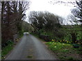
The ancient causeway and its bridge
Now a minor road that links the A40 with Mathry and the road to St David's, this was formerly a raised causeway, possibly of Neolithic date, across the boggy valley of the upper Cleddau. As explained by Damien Walford Davies and Anne Eastham in their book 'Saints and Stones', Gomer, 2002, "The causeway is constructed of huge Preseli boulders, interlocking with each other and rising and falling with the water levels in the marsh or lake bed beneath....In 4000 years or so of use, smaller stones and layers of water macadam have been added by generations of road menders to build up the carriageway,until in the 19th century culm and rubble with fragments of pottery became incorporated in the fill and parapets were added" to the bridge.
Image: © Natasha Ceridwen de Chroustchoff
Taken: 28 Apr 2010
0.04 miles
5
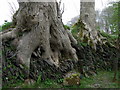
Tree boles
Like the claws of some gigantic bird gripping on to the old walling.
Image: © Natasha Ceridwen de Chroustchoff
Taken: 28 Apr 2010
0.06 miles
6
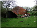
Collapsed barn
Dutch barn has folded in on itself in a dramatic fashion, like a downed aircraft.
Image: © Natasha Ceridwen de Chroustchoff
Taken: 28 Apr 2010
0.07 miles
7
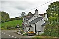
Cottage On The A40 Just Outside Scleddau
I do not know the name of the building
Image: © Deborah Tilley
Taken: 25 May 2015
0.11 miles
9
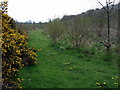
New plantation
This strip of land between the A40 and the river was planted with a mixture of broadleafed trees a few years back and they're coming on nicely.
Image: © Natasha Ceridwen de Chroustchoff
Taken: 28 Apr 2010
0.14 miles
10
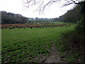
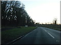
The Cleddau valley below Scleddau
The same place as Image] but looking in the opposite direction, with the river on the left, the hanging woods on the right. The A40 road climbs the ridge due south.
The village of Scleddau, named after the river, lies behind the photographer.
Image: © Natasha Ceridwen de Chroustchoff
Taken: 28 Apr 2010
0.16 miles