IMAGES TAKEN NEAR TO
High Street, FISHGUARD, SA65 9AU
Introduction
This page details the photographs taken nearby to High Street, SA65 9AU by members of the Geograph project.
The Geograph project started in 2005 with the aim of publishing, organising and preserving representative images for every square kilometre of Great Britain, Ireland and the Isle of Man.

There are currently over 7.5m images from over14,400 individuals and you can help contribute to the project by visiting https://www.geograph.org.uk
Image Map
Images are licensed for reuse under creativecommons.org/licenses/by-sa/2.0
Notes
- Clicking on the map will re-center to the selected point.
- The higher the marker number, the further away the image location is from the centre of the postcode.
Image Listing (264 Images Found)
Images are licensed for reuse under creativecommons.org/licenses/by-sa/2.0
Image
Details
Distance
1
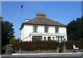
Former rectory, Heol Fawr/High Street
Llys Mair was built in 1830 for the Rev. Samuel Fenton and stands at the southern edge of the town. It has not been treated kindly over the years and the C20 extension at the front is especially regrettable.
Image: © Natasha Ceridwen de Chroustchoff
Taken: 22 Aug 2007
0.01 miles
2
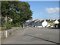
A40 into Fishguard
From Maesgwynne Road. Off to the right is Carreg Onnen, leading to a caravan park.
Image: © Pauline E
Taken: 16 Sep 2009
0.02 miles
3
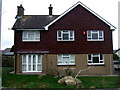
The Vicarage
Stark modern version standing next door to the old rectory Image
Driftwood cross in front garden.
Image: © Natasha Ceridwen de Chroustchoff
Taken: 8 Feb 2008
0.02 miles
4
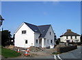
New house, a few months later
This is the house seen here Image under construction in April 2007, now (August) well on the way to completion.
Image: © Natasha Ceridwen de Chroustchoff
Taken: 22 Aug 2007
0.04 miles
6
Decorative railings, Lota Park
The southern gateway to Lota Park is adorned, like the northern entrance, with images of ships and a railways engines past and present to commemorate the centenary of the ferry crossing.
It is the work of the Dinas blacksmith Eifion Thomas and sons.
Image: © Natasha Ceridwen de Chroustchoff
Taken: 8 Feb 2008
0.05 miles
7
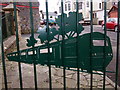
Decorative railings, Lota Park
The southern gateway to Lota Park is adorned, like the northern entrance, with images of ships and railway engines past and present.
They are the work of the Thomas family of local blacksmiths, hence the maker's mark 'JET Dinas'.
Image: © Natasha Ceridwen de Chroustchoff
Taken: 8 Feb 2008
0.05 miles
8
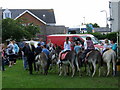
Fishguard carnival 2010 (8)
Donkey rides in Lota Park.
Image: © Natasha Ceridwen de Chroustchoff
Taken: 28 Aug 2010
0.06 miles
9
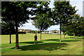
Parc Lota/Lota Park, Abergwaun/Fishguard
Looking NE from the top of the park.
Regarding the history and name of the park see http://www.geograph.org.uk/photo/331768
Image: © Natasha Ceridwen de Chroustchoff
Taken: 10 Jul 2017
0.06 miles
10

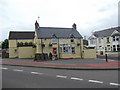
Pendre Inn, Abergwaun/Fishguard
Pendre, 'top of the town' in Welsh, was the site of one of the tollgates that became the focus of the Rebecca Riots in the 1840's. Local people across south and west Wales, dressed as women for disguise, caused mayhem when they protested against extortionate charges for the use of turnpike roads. In September 1843 several hundred rioters tore down the Fishguard tollgate and fired muskets.
Image: © Natasha Ceridwen de Chroustchoff
Taken: 8 Nov 2006
0.07 miles