IMAGES TAKEN NEAR TO
Troed Y Rhiw, GOODWICK, SA64 0AU
Introduction
This page details the photographs taken nearby to Troed Y Rhiw, SA64 0AU by members of the Geograph project.
The Geograph project started in 2005 with the aim of publishing, organising and preserving representative images for every square kilometre of Great Britain, Ireland and the Isle of Man.

There are currently over 7.5m images from over14,400 individuals and you can help contribute to the project by visiting https://www.geograph.org.uk
Image Map
Images are licensed for reuse under creativecommons.org/licenses/by-sa/2.0
Notes
- Clicking on the map will re-center to the selected point.
- The higher the marker number, the further away the image location is from the centre of the postcode.
Image Listing (23 Images Found)
Images are licensed for reuse under creativecommons.org/licenses/by-sa/2.0
Image
Details
Distance
1
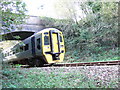
Railway bridge, Trefwrgi Road, Wdig/Goodwick
Fishguard's once-daily train from Cardiff (connecting with London etc.) is seen here seconds from its destination at the ferry terminal. It will pick up passengers and start the return journey in less than half an hour. There is another such train service in the middle of the night.
Image: © Natasha Ceridwen de Chroustchoff
Taken: 9 Nov 2006
0.06 miles
2
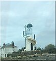
Croeso i Wdig/Goodwick
Decorative lighthouse on the approach to Goodwick on the A487
Image: © Eirian Evans
Taken: 5 Apr 2022
0.09 miles
3
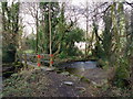
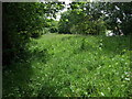
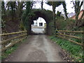
Footbridge over Goodwick Brook near The Drim
Seems to be the course of an old path leading from Dyffryn to The Drim. Old stone building was ?a mill.
Image: © Natasha Ceridwen de Chroustchoff
Taken: 3 Feb 2011
0.11 miles
4
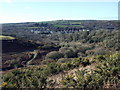
Long view towards Goodwick and Pencaer
An exceptionally clear afternoon produces a remarkably long vista: in the foreground, the scrubby slope leading down to Cwm Brandy and, beyond the wooded area, the western part of Goodwick along the A487 St David's road. Above, just visible, are the farms of Trefwrgi (right) and Tre-Llewelyn (left, amongst dark trees), while the pimple on the skyline is the highest point on Pencaer, at 213 metres, the rocky peak of Garn Fawr on the west-facing coast.
Image: © Natasha Ceridwen de Chroustchoff
Taken: 11 Feb 2009
0.11 miles
5
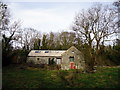
Old building near the Drim
This substantial building at the Drim could have been a barn or store house associated with the gentry house and farm or with the nearby mill. It has had some renovation but at the time of the photograph appeared disused.
Image: © Natasha Ceridwen de Chroustchoff
Taken: 3 Feb 2011
0.12 miles
6
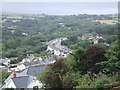
View over Dyffryn
Going up from the centre of Goodwick/Wdig towards Stop and Call, a view opens to the south of Dyffryn and the curving terrace of Heol y Felin. This section of road was relieved of its heavy, nocturnal, ferry-bound traffic by the construction of a new by-pass a few years ago.
Image: © Natasha Ceridwen de Chroustchoff
Taken: 9 Aug 2006
0.13 miles
7
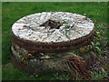
Millstone at the Drim
There was a mill once at this location just below the road, east of the road leading out of Goodwick towards St David's. A good deal of rebuilding and conversion has taken place with the mill becoming a hotel. Two millstones remain to mark its former significance.
Image: © Natasha Ceridwen de Chroustchoff
Taken: 1 Apr 2009
0.14 miles
8
Ghost of a railway
This was the route of a planned cut-off to provide an improved railway link between Goodwick with Letterston. The bends and gradient of the existing one were proving troublesome for the rolling stock and the idea was to replace the line with one running through Manorowen Wood. Work ceased when WW1 broke out in 1914 but two bridges remain, one immediately to the right of the image, and some of the cuttings where the tracks would have been laid.
Image: © Natasha Ceridwen de Chroustchoff
Taken: 17 Jun 2008
0.15 miles
9
Railway bridge that never was
This bridge was built in 1908 to carry an alternative line from Goodwick to Letterston that was never completed although a mile or so of embankment still remains to the west of it. The scheme was interrupted by the outbreak of WW1.
Image: © Natasha Ceridwen de Chroustchoff
Taken: 1 Apr 2009
0.15 miles
10
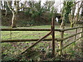
Embankment and broad gauge railway line
Here, just below The Drim and looking west towards the Dyffryn area of Goodwick, are some interesting railway relics. In the foreground is a fence post made from redundant sections of the old 7 foot gauge railway line adopted by Brunel for the GWR and used until 1892 when all tracks were converted to standard gauge.
Behind can be seen an embankment and bridge constructed with the intention of opening an alternative route for the line between Goodwick station and Letterston junction. The scheme was interrupted by WW1 and never completed.
[Thanks to Roy Lewis for the information about the Brunel gauge fencing.]
Image: © Natasha Ceridwen de Chroustchoff
Taken: 3 Feb 2011
0.17 miles