IMAGES TAKEN NEAR TO
St. Davids, HAVERFORDWEST, SA62 6QN
Introduction
This page details the photographs taken nearby to SA62 6QN by members of the Geograph project.
The Geograph project started in 2005 with the aim of publishing, organising and preserving representative images for every square kilometre of Great Britain, Ireland and the Isle of Man.

There are currently over 7.5m images from over14,400 individuals and you can help contribute to the project by visiting https://www.geograph.org.uk
Image Map
Images are licensed for reuse under creativecommons.org/licenses/by-sa/2.0
Notes
- Clicking on the map will re-center to the selected point.
- The higher the marker number, the further away the image location is from the centre of the postcode.
Image Listing (42 Images Found)
Images are licensed for reuse under creativecommons.org/licenses/by-sa/2.0
Image
Details
Distance
1
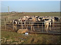
Ponies at Caer Nwchwn
They are spending the winter here before...a French vacation maybe?
Image: © Deborah Tilley
Taken: 30 Dec 2008
0.03 miles
4
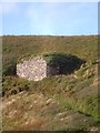
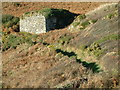
Lime Kiln above Caer Bwdy Bay
Coastal lime kilns are quite common around the Pembrokeshire coast, usually placed above a beach or harbour where limestone could be brought in by boat from sources in the south of the county. Those by the harbour at Solva [SM8024] are probably the best known.
Image: © Gordon Hatton
Taken: 24 Oct 2013
0.13 miles
6
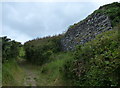
Lime kiln along the Pembrokeshire Coast Path
At Caer Bwdy Bay.
Image: © Mat Fascione
Taken: 5 Jun 2019
0.14 miles
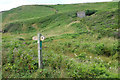
7
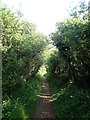
Wales Coast Path
Between high hedges on the way to Caer Bwdy Bay
Image: © Eirian Evans
Taken: 29 Apr 2022
0.14 miles
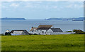
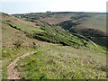
8
Coast path above Caer Bwdy Bay
The coast path heads through a sea of gorse and bracken along the cliff tops of the south side of the St David's peninsula.
Image: © Stephen McKay
Taken: 18 Jul 2019
0.15 miles
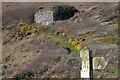
9
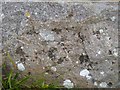
Worn benchmark on limekiln, Caer Bwdy Bay, Pembrokeshire
A very worn Ordnance Survey benchmark on a limekiln at Caer Bwdy Bay on the Pembrokeshire coastal path. The benchmark is described on the database at http://www.bench-marks.org.uk/bm67268.
Image: © Becky Williamson
Taken: 24 Sep 2015
0.15 miles