IMAGES TAKEN NEAR TO
Mathry Road, HAVERFORDWEST, SA62 5EE
Introduction
This page details the photographs taken nearby to Mathry Road, SA62 5EE by members of the Geograph project.
The Geograph project started in 2005 with the aim of publishing, organising and preserving representative images for every square kilometre of Great Britain, Ireland and the Isle of Man.

There are currently over 7.5m images from over14,400 individuals and you can help contribute to the project by visiting https://www.geograph.org.uk
Image Map
Images are licensed for reuse under creativecommons.org/licenses/by-sa/2.0
Notes
- Clicking on the map will re-center to the selected point.
- The higher the marker number, the further away the image location is from the centre of the postcode.
Image Listing (12 Images Found)
Images are licensed for reuse under creativecommons.org/licenses/by-sa/2.0
Image
Details
Distance
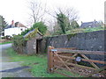
1
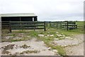
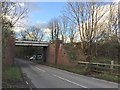
Road Junction, near Letterston
This photograph shows a view of the junction of the B4331 and the minor road to the A40, near the former railway station, Mathry Road Station. Beyond the double gates, covered by the overgrowth of brambles and vegetation, the
remains of the former cattle pens and market between the railway line and the minor road, especially the concrete floor and the corrugated metal buildings, can be seen.
Image: © Martyn Harries
Taken: 2 Apr 2010
0.02 miles
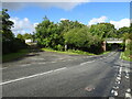
2
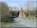
Railway Bridge
Railway Bridge over the B4331 heading towards Mathry from Letterston.By the bridge,was the site of Mathry Road station.The station was opened in 1923 as Mathry station,but was renamed Mathry Road.The station was closed in 1964.
Image: © Martyn Harries
Taken: 24 Mar 2009
0.04 miles
3
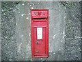
Victorian postbox, near Letterston
Victorian postbox is set into the wall by the old Mathry Road station.
Image: © Martyn Harries
Taken: 21 Sep 2009
0.04 miles
4
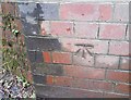
Ordnance Survey Cut Mark
This OS cut mark can be found on NE abutment of the railway bridge. It marks a point 60.186m above mean sea level.
Image: © Adrian Dust
Taken: 4 Mar 2020
0.05 miles
5
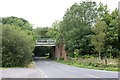
Railway Bridge, Mathry Road
The bridge carries the railway line from Clarbeston Road to Fishguard over the road between Letterston and St David's.
Image: © Simon Mortimer
Taken: 29 Aug 2013
0.05 miles
6
Railway Bridge
The Haverfordwest to Fishguard railway crosses the Letterston to Mathry road.
Image: © Alan Hughes
Taken: 7 Nov 2017
0.05 miles
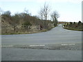
7
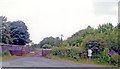
Site of Mathry Road station
View SW on the B4331(6), towards Clarbeston Road, Whitland, Carmarthen etc: ex-GWR South Wales main line to Fishguard. The line is up to the right and the station was ahead, closed 6/4/64. The station ('Mathry' until 1924) was about four miles from Mathry and was the nearest station to St David's - about 10 miles further west.
Image: © Ben Brooksbank
Taken: 23 Jun 2004
0.06 miles
8
Old railway station
This is the site of Mathry Road station, a halt on the old GWR line to Fishguard. Trains to the ferry terminal still pass twice a day but the station was closed in 1965. The retaining wall and the small stone building are evidently left over from that time.
Image: © Natasha Ceridwen de Chroustchoff
Taken: 8 Dec 2006
0.09 miles
9
Mathry Road Halt railway station (site), Pembrokeshire
Opened in 1923 by the Great Western Railway on the line from Carmarthen to Fishguard Harbour, this station closed in 1964.
View south west up the former approach road. The Halt was of entirely timber construction and lay between the top of the approach road and the railway bridge to the right. No trace of it apparently remains.
Image: © Nigel Thompson
Taken: 4 Sep 2022
0.10 miles