IMAGES TAKEN NEAR TO
Tangiers, HAVERFORDWEST, SA62 4BU
Introduction
This page details the photographs taken nearby to SA62 4BU by members of the Geograph project.
The Geograph project started in 2005 with the aim of publishing, organising and preserving representative images for every square kilometre of Great Britain, Ireland and the Isle of Man.

There are currently over 7.5m images from over14,400 individuals and you can help contribute to the project by visiting https://www.geograph.org.uk
Image Map (Loading...)


Getting Data...Please wait
Leaflet Map data © OpenStreetMap
Images are licensed for reuse under creativecommons.org/licenses/by-sa/2.0
Notes
- Clicking on the map will re-center to the selected point.
- The higher the marker number, the further away the image location is from the centre of the postcode.
Image Listing (11 Images Found)
Images are licensed for reuse under creativecommons.org/licenses/by-sa/2.0
Image
Details
Distance
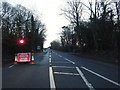
2
Ordnance Survey Flush Bracket (S7826)
This partially covered OS Flush Bracket can be found on the house to the east of the road. It marks a point 49.151m above mean sea level.
Image: © Adrian Dust
Taken: 6 Jul 2014
0.08 miles
3
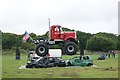
Giant truck display at Pembrokeshire County Sow
Image: © Simon Mortimer
Taken: 20 Aug 2015
0.12 miles
4
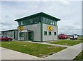
Control Tower, Haverfordwest (Withybush) Airport, Rudbaxton
The modern buildings contrast with the old fire engine, which no doubt is still in good working order!
Image: © Humphrey Bolton
Taken: 4 Jul 2008
0.14 miles
5
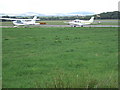
Withybush Airfield
The airfield lies a few miles north of Haverfordwest/Hwlfordd and is used for recreational flying and lessons, with no commercial flights. Beyond the planes the Mynydd Preseli can be seen in the distance.
Image: © Natasha Ceridwen de Chroustchoff
Taken: 26 Aug 2006
0.16 miles
6
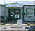
Terminal Building Haverfordwest (Withybush) Airport
The airport is used by light aircraft and helicopters.
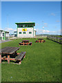
Cafe, toilets and picnic area available for enthusiasts.
Image: © Pauline E
Taken: 27 Sep 2007
0.16 miles
7

The Old Forge Gallery
Small gallery just North of Withybush Aerodrome entrance
http://www.oldforgegallery.co.uk
Image: © Bill Thornton
Taken: 1 Jun 2001
0.17 miles
8
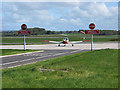
Haverfordwest (Withybush) Airport Runway
A Warrior light aircraft arrives from Gloucester. The windsock shows the strong north easterly wind down runway 03.
Image: © Pauline E
Taken: 27 Sep 2007
0.19 miles
9
Control Tower Haverfordwest (Withybush) Airport
Airfield first established in 1941 by the Ministry of Defence for use by the RAF.
Image: © Pauline E
Taken: 27 Sep 2007
0.19 miles
10
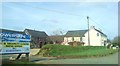
Tangiers and outbuildings
A curious placename to find in Wales.
Image: © Deborah Tilley
Taken: 16 Mar 2009
0.21 miles