IMAGES TAKEN NEAR TO
Portfield, HAVERFORDWEST, SA61 1BW
Introduction
This page details the photographs taken nearby to Portfield, SA61 1BW by members of the Geograph project.
The Geograph project started in 2005 with the aim of publishing, organising and preserving representative images for every square kilometre of Great Britain, Ireland and the Isle of Man.

There are currently over 7.5m images from over14,400 individuals and you can help contribute to the project by visiting https://www.geograph.org.uk
Image Map (Loading...)


Getting Data...Please wait
Leaflet Map data © OpenStreetMap
Images are licensed for reuse under creativecommons.org/licenses/by-sa/2.0
Notes
- Clicking on the map will re-center to the selected point.
- The higher the marker number, the further away the image location is from the centre of the postcode.
Image Listing (70 Images Found)
Images are licensed for reuse under creativecommons.org/licenses/by-sa/2.0
Image
Details
Distance
1
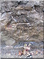
Ordnance Survey Cut Mark
This OS cut mark can be found on the wall of No44 Portfield. It marks a point 55.320m above mean sea level.
Image: © Adrian Dust
Taken: 22 Aug 2015
0.02 miles
2
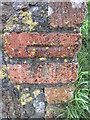
Ordnance Survey Cut Mark
This OS cut mark can be found at the bottom of the steps on Jury Lane. It marks a point 53.969m above mean sea level.
Image: © Adrian Dust
Taken: 22 Aug 2015
0.03 miles
3
Ordnance Survey Cut Mark
This OS cut mark can be found on the SW angle of the Infant School. It marks a point 50.661m above mean sea level.
Image: © Adrian Dust
Taken: 22 Aug 2015
0.07 miles
4
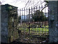
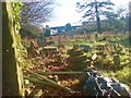
Padlocked cemetery
This little cemetery at the top of Barn Street is firmly locked and looks neglected, the graves overgrown and rubbish strewn around. A large supermarket looms behind.
Image: © Natasha Ceridwen de Chroustchoff
Taken: 27 Jan 2007
0.08 miles
5
Former school toilets off Portfield, Haverfordwest
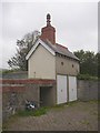
This is behind the disused school at the top of Barn Street. A former pupil of the School in the sixties has informed me that the building is the former school toilets. After the closure of the school the site was taken over by Pembrokeshire College and the toilets retained. The old school was purchased from the College and converted to Business use. It was at this time that the old doors were removed from the toilets and the outside rendered. Behind this building there was an old wartime bomb shelter, probably demolished by now.
Image: © Humphrey Bolton
Taken: 1 Oct 2007
0.09 miles
6
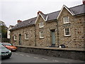
The uppermost Perrot almshouses, Barn Street, Haverfordwest
The top house is different from the others in having no gables. 'Pevsner' states that the building started at the top end.
Image: © Humphrey Bolton
Taken: 1 Oct 2007
0.09 miles
7
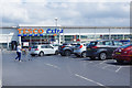
Tesco Extra, Haverfordwest
Tesco's large Haverfordwest store is located just off the town centre on the Fenton Trading Estate. It ceased opening on a 24-hour basis in 2016, the company saying that the rise of the internet home delivery service meant that very few customers were using the shop between midnight and 0600.
Image: © Stephen McKay
Taken: 16 Jul 2019
0.11 miles
8
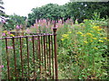
Cemetery wilderness
The cemetery that was locked in February Image was open this time, overgrown with colourful ragwort and rosebay willowherb growing unchecked over the neglected graves.
Image: © Natasha Ceridwen de Chroustchoff
Taken: 21 Jul 2007
0.11 miles
9
Ruinous graveyard at Albert Street
Closed to the public, I'm not sure which church this belongs to. St Martin's is the nearest.
Image: © Deborah Tilley
Taken: 1 Dec 2008
0.11 miles
10
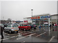
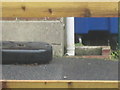
Haverford - Tesco Extra Supermarket Entrance
Image: © James Emmans
Taken: 13 Dec 2016
0.11 miles