IMAGES TAKEN NEAR TO
Maes Morrison, SWANSEA, SA4 8EB
Introduction
This page details the photographs taken nearby to Maes Morrison, SA4 8EB by members of the Geograph project.
The Geograph project started in 2005 with the aim of publishing, organising and preserving representative images for every square kilometre of Great Britain, Ireland and the Isle of Man.

There are currently over 7.5m images from over14,400 individuals and you can help contribute to the project by visiting https://www.geograph.org.uk
Image Map (Loading...)


Getting Data...Please wait
Leaflet Map data © OpenStreetMap
Images are licensed for reuse under creativecommons.org/licenses/by-sa/2.0
Notes
- Clicking on the map will re-center to the selected point.
- The higher the marker number, the further away the image location is from the centre of the postcode.
Image Listing (34 Images Found)
Images are licensed for reuse under creativecommons.org/licenses/by-sa/2.0
Image
Details
Distance
1
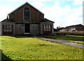
Y Babell chapel, Pontarddulais
Set back 35 metres from the south side of the A48 Bolgoed Road.
There is no nameboard here, only Y BABELL engraved in stone on the doorway arch.
Image: © Jaggery
Taken: 14 Feb 2015
0.12 miles
2
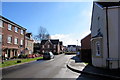
Towards Cwrt Rebecca from the corner of Heol Daniel, Pontarddulais
Viewed along Birch Rock Road in an area of houses built c2010 on the south side of the A48 Bolgoed Road.
Image: © Jaggery
Taken: 14 Feb 2015
0.13 miles
3
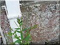
Ordnance Survey Cut Mark
This OS cut mark can be found on No90 Bolgoed Road. It marks a point 33.065m above mean sea level.
Image: © Adrian Dust
Taken: 7 Jul 2021
0.14 miles
4
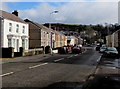
Bolgoed Road in Pontarddulais
The A48 has various names on its route through Pontarddulais. Here it is Bolgoed Road.
Image: © Jaggery
Taken: 14 Feb 2015
0.14 miles
5
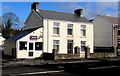
Short Bark 'n' Side in Pontarddulais
Dog grooming parlour at 55 Bolgoed Road, opposite Ffordd y Glowr.
Image: © Jaggery
Taken: 14 Feb 2015
0.14 miles
6
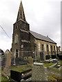
Fenced-off church tower in Pontarddulais
In February 2015, the western edge of St Teilo's Church is fenced off.
Twigs protrude from the top of the tower.
Image: © Jaggery
Taken: 14 Feb 2015
0.14 miles
7
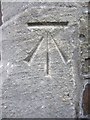
Ordnance Survey Cut Mark
This OS cut mark can be found on the tower of St Teilo's Church. It marks a point 35.549m above mean sea level. http://www.geograph.org.uk/photo/3698557
Image: © Adrian Dust
Taken: 13 Oct 2013
0.14 miles
8
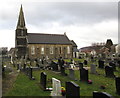
St Teilo's churchyard, Pontarddulais
About two-thirds of the churchyard is on this (the south) side of the church in the
Church in Wales Parish of Llandeilo Tal-y-Bont in the Diocese of Swansea & Brecon.
Image: © Jaggery
Taken: 14 Feb 2015
0.15 miles
9
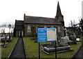
St Teilo's Church in Pontarddulais
Set back 30 metres from the south side of Church Lane, St Teilo's is part of
the Church in Wales Parish of Llandeilo Tal-y-Bont in the Diocese of Swansea & Brecon.
Image: © Jaggery
Taken: 14 Feb 2015
0.15 miles
10
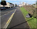
Wind damage in Pontarddulais
Blown inside out, an umbrella has been dumped at the edge of the A48 Bolgoed Road.
Image: © Jaggery
Taken: 14 Feb 2015
0.15 miles