IMAGES TAKEN NEAR TO
Allt Y Graban Road, SWANSEA, SA4 8DU
Introduction
This page details the photographs taken nearby to Allt Y Graban Road, SA4 8DU by members of the Geograph project.
The Geograph project started in 2005 with the aim of publishing, organising and preserving representative images for every square kilometre of Great Britain, Ireland and the Isle of Man.

There are currently over 7.5m images from over14,400 individuals and you can help contribute to the project by visiting https://www.geograph.org.uk
Image Map
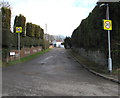
Images are licensed for reuse under creativecommons.org/licenses/by-sa/2.0
Notes
- Clicking on the map will re-center to the selected point.
- The higher the marker number, the further away the image location is from the centre of the postcode.
Image Listing (16 Images Found)
Images are licensed for reuse under creativecommons.org/licenses/by-sa/2.0
Image
Details
Distance
1
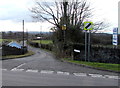
Junction for Pontarddulais Garden Centre
At the eastern edge of Pontarddulais, near the Pontlliw boundary, Allt-y-Graban Road heads south
away from the A48. A sign on the right points towards Pontarddulais Garden Centre & Restaurant.
Image: © Jaggery
Taken: 14 Feb 2015
0.02 miles
2
Allt-y-Graban Road for Pontarddulais Garden Centre
From the A48, where a sign pointing this way shows Pontarddulais Garden Centre & Restaurant.
Image: © Jaggery
Taken: 14 Feb 2015
0.02 miles
3
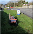
Roadside bench in Pontlliw
Alongside the A48 near the Pontarddulais boundary.
Image: © Jaggery
Taken: 14 Feb 2015
0.02 miles
4
NW boundary sign for Pontlliw
Viewed across the A48 near the SE edge of Pontarddulais. Pontlliw is a village in the City and County of Swansea.
Image: © Jaggery
Taken: 14 Feb 2015
0.03 miles
5

Ordnance Survey Cut Mark
This OS cut mark can be found on the wall of Gors Las SW side of the road. It marks a point 55.181m above mean sea level.
Image: © Adrian Dust
Taken: 27 Mar 2021
0.06 miles
6
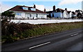
Bryntiron Road houses, Pontlliw
Viewed across the A48 Bryntiron Road in the north of Pontlliw.
Image: © Jaggery
Taken: 14 Feb 2015
0.07 miles
7

Unsuitable for heavy goods vehicles, Heol-y-Barna, Pontlliw
Heol-y-Barna heads north away from the A48.
Image: © Jaggery
Taken: 14 Feb 2015
0.07 miles
8
20mph speed limit towards Bryntirion Road houses in Pontlliw
Viewed near the Heol-y-Barna junction. http://www.geograph.org.uk/photo/4348302 The street name sign shows Bryntirion Road 185-202.
Image: © Jaggery
Taken: 14 Feb 2015
0.07 miles
9
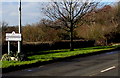
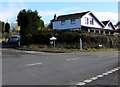
SE boundary of Pontarddulais
The A48 passes from the village of Pontlliw to the town of Pontarddulais. Formerly in the county of Glamorgan and later West Glamorgan, both locations are now in the City and County of Swansea.
The boundary sign shows that Pontarddulais is twinned with Hourtin (France).
Image: © Jaggery
Taken: 14 Feb 2015
0.09 miles
10

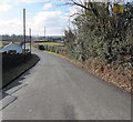
Lay-by off A48
Where the A 48 has been straightened, the old bend has been turned into a lay-by.
Image: © Alan Hughes
Taken: 19 Nov 2018
0.11 miles