IMAGES TAKEN NEAR TO
Sarn Helen, LAMPETER, SA48 8HW
Introduction
This page details the photographs taken nearby to Sarn Helen, SA48 8HW by members of the Geograph project.
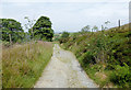
The Geograph project started in 2005 with the aim of publishing, organising and preserving representative images for every square kilometre of Great Britain, Ireland and the Isle of Man.

There are currently over 7.5m images from over14,400 individuals and you can help contribute to the project by visiting https://www.geograph.org.uk
Image Map
Images are licensed for reuse under creativecommons.org/licenses/by-sa/2.0
Notes
- Clicking on the map will re-center to the selected point.
- The higher the marker number, the further away the image location is from the centre of the postcode.
Image Listing (23 Images Found)
Images are licensed for reuse under creativecommons.org/licenses/by-sa/2.0
Image
Details
Distance
1
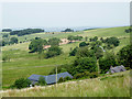
Farmland south-east of Llanfair Clydogau, Carmarthenshire
A telephoto assisted image looking north-west from near the cattlegrid on the road (Sarn Helen) by Esgair Fraith. The buildings are at Lluest-y-bwlch.
Image: © Roger D Kidd
Taken: 21 Jun 2017
0.02 miles
2
Rough pasture south-east of Llanfair-Clydogau, Carmarthenshire
The farm house at Lluest-y-bwlch is to the right of the larger new building
Image: © Roger D Kidd
Taken: 21 Jun 2017
0.04 miles
3
Halfway Inn
Ar ochr chwith o'r hewl (sef Hewl Rufeinig!) y safai Tafarn yr Halfway ac o leiaf o 1881 hyd at 1911 y tafarnwraig oedd Hannah Jones. Trigai yno gyda'i merch, Mary.
On the left of the road (a Roman Road!) are the scant remains of the Halfway Inn. From at least 1881 until 1911 the occupants was Hannah Jones 'licensed victualler' and her daughter, Mary.
Image: © Alan Richards
Taken: 4 Jun 2011
0.06 miles
4
Stony road north of Llanycrwys in Carmarthenshire
The stony road from the southern part of the Clywedog Plantation and the Twrch valley approaches the lane (Sarn Helen) between Llanycrwys and Llanfair Clydogau.
Image: © Roger D Kidd
Taken: 21 Jun 2017
0.07 miles
5
Forestry road north of Llanycrwys in Carmarthenshire
The stony road from the southern part of the Clywedog Plantation and the Twrch valley approaches the lane (Sarn Helen) between Llanycrwys and Llanfair Clydogau.
Image: © Roger D Kidd
Taken: 21 Jun 2017
0.07 miles
6
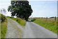
Lane to Llanycrwys in Carmarthenshire
This is probably part of the course followed by the Roman Sarn Helen, about two miles south-east of Llanfair Clydogau. The stony road off to the left leads through fields of rough pasture to the southern part of the Clywedog Plantation.
See also http://www.geograph.org.uk/photo/4076938
Image: © Roger D Kidd
Taken: 21 Jun 2017
0.08 miles
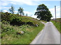
7
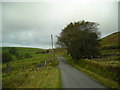
Lane to Llanfair Clydogau, Carmarthenshire
Looking north from near Esgair Fraith, this was part of the Roman Sarn Helen road. The route is named after Saint Elen of Caernarfon.
Image: © Roger D Kidd
Taken: 21 Jun 2017
0.08 miles
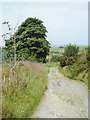
8
Sarn Helen
Taken in the extreme south of this gridsquare looking along Sarn Helen Roman road. On the left is the beginning of a track to Lluest-y-bwlch and on the right is a clump of trees that mark the site of a house called Bwlch-y-ffin
Image: © Dan Gregory
Taken: 9 Oct 2007
0.09 miles
9
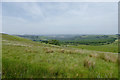
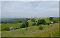
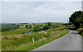
Rough pasture south-east of Llanfair Clydogau, Carmarthenshire
Looking from Sarn Helen towards the forestry of Coed Llwynifan.
Image: © Roger D Kidd
Taken: 21 Jun 2017
0.10 miles
10
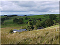
View over Lluest-y-bwlch
With the roofs of the farm buildings seen close by.
Image: © Nigel Brown
Taken: 24 Sep 2010
0.10 miles