IMAGES TAKEN NEAR TO
Aberarth, ABERAERON, SA46 0LR
Introduction
This page details the photographs taken nearby to SA46 0LR by members of the Geograph project.
The Geograph project started in 2005 with the aim of publishing, organising and preserving representative images for every square kilometre of Great Britain, Ireland and the Isle of Man.

There are currently over 7.5m images from over14,400 individuals and you can help contribute to the project by visiting https://www.geograph.org.uk
Image Map
Images are licensed for reuse under creativecommons.org/licenses/by-sa/2.0
Notes
- Clicking on the map will re-center to the selected point.
- The higher the marker number, the further away the image location is from the centre of the postcode.
Image Listing (48 Images Found)
Images are licensed for reuse under creativecommons.org/licenses/by-sa/2.0
Image
Details
Distance
2
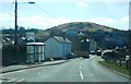
Road bridge over Afon Arth
Carries the A487 road through Aberarth.
Image: © John Lucas
Taken: 23 Mar 2016
0.03 miles
3
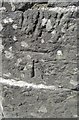
Ordnance Survey Benchmark and Bolt - Aberarth Bridge
Ordnance Survey Benchmark (OSBM) used for levelling height above Ordnance Datum (OD).
Height: 14.2006m OD (Newlyn). Mark verified by the Ordnance Survey in 1977. Description: PARA BR NW SIDE RD 15.2M SW ANG WALL. 0.4m above ground. 3rd Order BM.
The bolt was used on the Warrington to Pembroke Docks line of the First Primary Levelling of England & Wales in 1851-1852. It was levelled with a height of 46.586' above OD (Liverpool). Description: 660. Bolt in West battlement of Aber Arth Bridge ; 5.00 ft. above lower surface of keystone. Page 534 of the abstract: http://www.trigtools.co.uk/data/1GL/1GLA_534.png
Image: © N Scott
Taken: 17 Jul 2013
0.04 miles
4
A487 Aberarth
View from the road bridge crossing the Afon Arth. Shot from the car hence the reflections.
Image: © wfmillar
Taken: 21 Feb 2014
0.04 miles
5

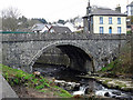
Pont Aberarth
The bridge at Aberarth carrying the A487 Ceredigion coast road dates from 1849 and was designed by Thomas Penson of Oswestry.
Image: © Stephen McKay
Taken: 12 Jul 2015
0.04 miles
6
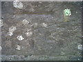
Ordnance Survey 1GL Bolt
This OS Bolt can be found on the NW parapet of the bridge. It marks a point 14.201m above mean sea level.
Image: © Adrian Dust
Taken: 26 Aug 2016
0.04 miles
7
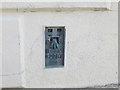
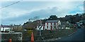
Ordnance Survey Flush Bracket G2987
This can be found on the wall of a private dwelling in Aberarth.
For more detail see : http://www.bench-marks.org.uk/bm180
Image: © Peter Wood
Taken: 21 Apr 2015
0.04 miles
8
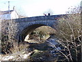
Pont Aberarth
Pont Aberarth a adeiladwyd yn 1849 ar ol i'r bont flaenorol gael ei dinsitrio gan lif yn 1846. Llifa Afon Arth - un o nifer o afonydd a enwir ar ol anifeilaid yng Nghymru - i mewn i Fae Ceredigion gerllaw.
Pont Aberarth was built in 1849 after the previous bridge was destroyed by a flood. 'Arth' is the Welsh name for 'bear' - one of many river names in Wales named after animals. The river flows into Cardigan Bay a short distance away.
Image: © Alan Richards
Taken: 13 Mar 2011
0.05 miles
9
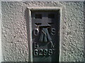
OSBM Flush Bracket G2987 - Aberarth, Bank
Ordnance Survey Benchmark (OSBM) used for levelling height above Ordnance Datum (OD).
Height (1956): 14.5519m OD (Newlyn). Mark verified by the Ordnance Survey in 1977. Description: FL BR G2987 HO ALICIA SE SIDE RD N ANG NW FACE. 0.5m above ground. 1st Order BM. The building is now a private house called Alicia.
The bracket was used on the Cardigan to Aberystwyth line (G082) of the Third Geodetic Levelling of England & Wales in 1956. Description: NW face, N angle of bank, SE side of road. Abstract G 65: http://discovery.nationalarchives.gov.uk/SearchUI/details?Uri=C11264473 [OS 54/754]
Context: Image
Image: © N Scott
Taken: 17 Jul 2013
0.05 miles
10

OSBM Flush Bracket G2987 - Aberarth, Bank
Ordnance Survey Benchmark (OSBM) used for levelling height above Ordnance Datum (OD).
Height (1956): 14.5519m OD (Newlyn). Mark verified by the Ordnance Survey in 1977. Description: FL BR G2987 HO ALICIA SE SIDE RD N ANG NW FACE. 0.5m above ground. 1st Order BM. The building is now a private house called Alicia.
The bracket was used on the Cardigan to Aberystwyth line (G082) of the Third Geodetic Levelling of England & Wales in 1956. Description: NW face, N angle of bank, SE side of road. Abstract G 65: http://discovery.nationalarchives.gov.uk/SearchUI/details?Uri=C11264473 [OS 54/754]
Close-up: Image
Image: © N Scott
Taken: 17 Jul 2013
0.05 miles