IMAGES TAKEN NEAR TO
Princes Avenue, ABERAERON, SA46 0JJ
Introduction
This page details the photographs taken nearby to Princes Avenue, SA46 0JJ by members of the Geograph project.
The Geograph project started in 2005 with the aim of publishing, organising and preserving representative images for every square kilometre of Great Britain, Ireland and the Isle of Man.

There are currently over 7.5m images from over14,400 individuals and you can help contribute to the project by visiting https://www.geograph.org.uk
Image Map
Images are licensed for reuse under creativecommons.org/licenses/by-sa/2.0
Notes
- Clicking on the map will re-center to the selected point.
- The higher the marker number, the further away the image location is from the centre of the postcode.
Image Listing (223 Images Found)
Images are licensed for reuse under creativecommons.org/licenses/by-sa/2.0
Image
Details
Distance
1
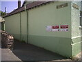
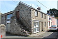
Aberaeron Union Workhouse/Cottage Hospital
Aberayron Poor Law Union was the first in Cardiganshire to open a workhouse, which was built in 1839-40, by William Green, to designs of George Wilkinson. It was converted for use as a hospital for injured soldiers in 1914 and became a cottage hospital in 1930. The hospital closed in 2019, when the new Integrated Care Centre opened at the Minaeron site, Vicarage Hill. The building was demolished in 2021.
Side: Image
Image: © N Scott
Taken: 17 Jul 2013
0.04 miles
2
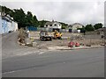
Site of Aberaeron Union Workhouse/Cottage Hospital
George Wilkinson's 1839-40 workhouse building was demolished in October 2021.
Image: © N Scott
Taken: 12 Jul 2024
0.04 miles
3
Aberaeron Union Workhouse/Cottage Hospital
This face of the building bore OSBM flush bracket S0449 at the East (left) angle:
The bracket was used on the Aberystwyth to Lampeter secondary line of the Second Geodetic Levelling of England & Wales in 1942. It was levelled with a height of 43.956' above OD (Newlyn). Description: E angle of workhouse, Aberayron. Abstract A 483: http://discovery.nationalarchives.gov.uk/details/r/C11178827 [OS 54/148]
The bracket, which had been obscured by rendering, was replaced by G2986 on the Midland Bank for the Third Geodetic Levelling in 1956.
Front: Image
Image: © N Scott
Taken: 17 Jul 2013
0.05 miles
4
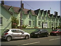
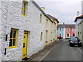
Coloured Houses of West Wales (14)
These houses are on North St the main road (the A487) through the town and out along the coast heading north.
Image: © Nigel Mykura
Taken: 1 Jul 2015
0.05 miles
5
Veterinary Surgery. Pant y Gof/Darkgate Street, Aberaeron
Surgery in an old stone building on a street corner, the row of houses further down the street are painted in different colours - a characteristic of streets in Aberaeron.
Image: © M J Roscoe
Taken: 23 Sep 2017
0.06 miles
6
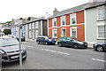
Pant Y Gof
This old residential street is on the edge of Aberaeron and runs from South Road just behind the photographer to North Road where the blue and pink houses are and which is just in the next grid square SN4562.
Image: © Nigel Mykura
Taken: 1 Jul 2015
0.06 miles
7
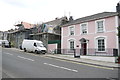
Houses on North Road
These houses are on the A487, the main road through town along the coast.
Image: © Nigel Mykura
Taken: 1 Jul 2015
0.06 miles
8
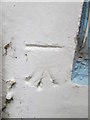
Ordnance Survey Cut Mark
This OS cut mark can be found on No8 North Road. It marks a point 5.447m above mean sea level.
Image: © Adrian Dust
Taken: 15 Jun 2014
0.07 miles
9
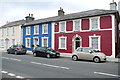
Coloured Houses of West Wales (13)
These bright blue and plum coloured houses are on the north side of North St the A487 the main road through the town. They are in the very north east corner of the grid square with a gridline to the left of them and another just behind them.
Image: © Nigel Mykura
Taken: 1 Jul 2015
0.07 miles
10
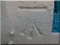
Ordnance Survey Benchmark - Aberaeron, 8 North Road
Ordnance Survey Benchmark (OSBM) used for levelling height above Ordnance Datum (OD).
Height: 5.447m OD (Newlyn). Mark verified by the Ordnance Survey in 1978. Description: NBM HO 8 NORTH RD S ANG SW FACE. 0.3m above ground. 3rd Order BM.
Context: Image
Image: © N Scott
Taken: 3 Jun 2023
0.07 miles