IMAGES TAKEN NEAR TO
Dark Gate Street, ABERAERON, SA46 0JH
Introduction
This page details the photographs taken nearby to Dark Gate Street, SA46 0JH by members of the Geograph project.
The Geograph project started in 2005 with the aim of publishing, organising and preserving representative images for every square kilometre of Great Britain, Ireland and the Isle of Man.

There are currently over 7.5m images from over14,400 individuals and you can help contribute to the project by visiting https://www.geograph.org.uk
Image Map
Images are licensed for reuse under creativecommons.org/licenses/by-sa/2.0
Notes
- Clicking on the map will re-center to the selected point.
- The higher the marker number, the further away the image location is from the centre of the postcode.
Image Listing (307 Images Found)
Images are licensed for reuse under creativecommons.org/licenses/by-sa/2.0
Image
Details
Distance
1
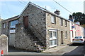
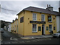
Veterinary Surgery. Pant y Gof/Darkgate Street, Aberaeron
Surgery in an old stone building on a street corner, the row of houses further down the street are painted in different colours - a characteristic of streets in Aberaeron.
Image: © M J Roscoe
Taken: 23 Sep 2017
0.01 miles
2
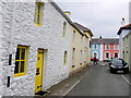
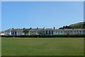
Pant Y Gof
This old residential street is on the edge of Aberaeron and runs from South Road just behind the photographer to North Road where the blue and pink houses are and which is just in the next grid square SN4562.
Image: © Nigel Mykura
Taken: 1 Jul 2015
0.01 miles
3
Alban Square, Aberaeron
Named after the Revd Alban Thomas Jones Gwynne whose early 19th century vision was responsible for creating the modern town. This shows the houses on the eastern side of the square, just off the main A487.
Image: © Stephen McKay
Taken: 23 Mar 2008
0.02 miles
4
Alban Square - HSBC - Sgwar Alban
Image: © G Williams
Taken: 22 Jun 2009
0.02 miles
5
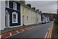
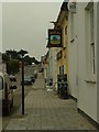
The Royal Oak & Pant Y Gof, Aberaeron
Pant Y Gof is also known as Darkgate Street.
Image: © Richard Law
Taken: 25 Oct 2008
0.03 miles
6
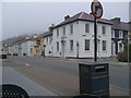
Ffordd y Gogledd
Y Dderwen Frenhinol ar Ffordd y Gogledd i Aberystwyth o Aberaeron ar y A487. Gwelwyd mynedfa i'r Pant y Gof ochr arall i'r Dderwen Frenhinol.
The Royal Oak on Ffordd y Gogledd (road) to Aberystwyth from Aberaeron on the A487. Entrance to Pant y Gof is seen the other side of the Royal Oak.
Image: © G Williams
Taken: 21 Jun 2009
0.03 miles
8
Croesffordd Sgwar Alban ar y A487 / Alban Square crossroad at A487
Y Dderwen Frenhinol a banc HSBC ar Ffordd Y Gogledd yn Aberaeron. Dynnwyd ar draws croesffordd ar y A487 wrth eistedd tu fas i Llond Plat. Heol unffyrdd ydi'r ddwy ochr Gorllewin i Dwyrain y cae sgwar Alban y dyddiau 'ma, fel gwelwyd ar y arwydd.
The Royal Oak and HSBC bank on Ffordd Y Gogledd at Aberaeron. Taken across crossroad on the A487 while sitting outside Llond Plat (Big Bite). One way road system enforced at the West to East sides of Alban square field nowadays; as seen on the roadsign.
Image: © G Williams
Taken: 2 Jun 2009
0.03 miles
9
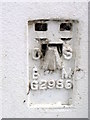
Flush Bracket G2986, Aberaeron
The flush bracket is to be found on the front of the HSBC Bank. For further information on the bracket http://www.bench-marks.org.uk/bm179
Image: © Maigheach-gheal
Taken: 19 Sep 2010
0.03 miles
10
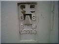
OSBM Flush Bracket G2986 - Aberaeron, Bank
Ordnance Survey Benchmark (OSBM) used for levelling height above Ordnance Datum (OD).
Height (1956): 5.6228m OD (Newlyn). Mark verified by the Ordnance Survey in 1978. Description: FL BR G2986 BANK 0.3M W ANG NW FACE SE SIDE BRIDGE RD. 0.4m above ground. 1st Order BM.
The bracket was used on the Cardigan to Aberystwyth line (G082) of the Third Geodetic Levelling of England & Wales in 1956.. Abstract G 65: http://discovery.nationalarchives.gov.uk/SearchUI/details?Uri=C11264473 [OS 54/754]
Context: Image
Image: © N Scott
Taken: 23 May 2012
0.03 miles