OSBM Flush Bracket G2986 - Aberaeron, Bank
Introduction
The photograph on this page of OSBM Flush Bracket G2986 - Aberaeron, Bank by N Scott as part of the Geograph project.
The Geograph project started in 2005 with the aim of publishing, organising and preserving representative images for every square kilometre of Great Britain, Ireland and the Isle of Man.

There are currently over 7.5m images from over 14,400 individuals and you can help contribute to the project by visiting https://www.geograph.org.uk
OSBM Flush Bracket G2986 - Aberaeron, Bank
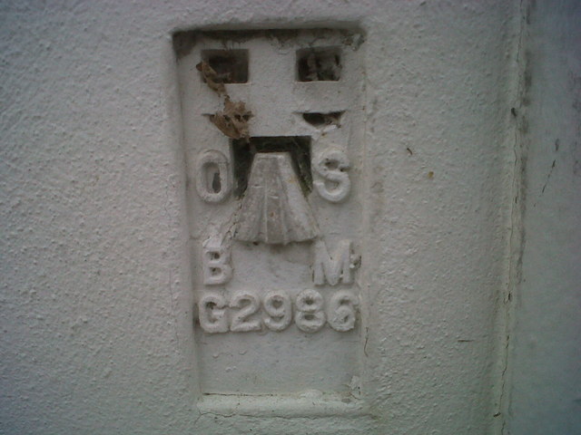
Image: © N Scott Taken: 23 May 2012
Ordnance Survey Benchmark (OSBM) used for levelling height above Ordnance Datum (OD). Height (1956): 5.6228m OD (Newlyn). Mark verified by the Ordnance Survey in 1978. Description: FL BR G2986 BANK 0.3M W ANG NW FACE SE SIDE BRIDGE RD. 0.4m above ground. 1st Order BM. The bracket was used on the Cardigan to Aberystwyth line (G082) of the Third Geodetic Levelling of England & Wales in 1956.. Abstract G 65: http://discovery.nationalarchives.gov.uk/SearchUI/details?Uri=C11264473 [OS 54/754] Context: Image
Images are licensed for reuse under creativecommons.org/licenses/by-sa/2.0
Image Location
Latitude
52.242938
Longitude
-4.25756