IMAGES TAKEN NEAR TO
Talgarreg, LLANDYSUL, SA44 4XJ
Introduction
This page details the photographs taken nearby to SA44 4XJ by members of the Geograph project.
The Geograph project started in 2005 with the aim of publishing, organising and preserving representative images for every square kilometre of Great Britain, Ireland and the Isle of Man.

There are currently over 7.5m images from over14,400 individuals and you can help contribute to the project by visiting https://www.geograph.org.uk
Image Map
Images are licensed for reuse under creativecommons.org/licenses/by-sa/2.0
Notes
- Clicking on the map will re-center to the selected point.
- The higher the marker number, the further away the image location is from the centre of the postcode.
Image Listing (5 Images Found)
Images are licensed for reuse under creativecommons.org/licenses/by-sa/2.0
Image
Details
Distance
1
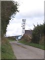
Telecommunications Mast
Telecommunications Mast at Mount Farm near Synod Inn just off the B4338.
Image: © Cered
Taken: 20 Sep 2005
0.07 miles
2
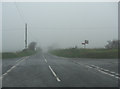
B4338 reaches its summit level
As befits a road reaching more than 900 feet AMSL this useful 'B' road is now into the base of the low stratus associated with a warm sector depression. This is hill fog, seen as an un-named minor road crosses near Pant-y-grugos. Looking closely the viewer can also make out red-mist; sprayed onto the signposts!
Image: © Stuart Logan
Taken: 8 Oct 2011
0.13 miles
3
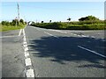
Crossroads south of Synod Inn
Crossroads on the A4338 to the south of Synod Inn.
Image: © Philip Halling
Taken: 16 Jul 2021
0.13 miles
4
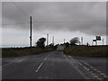
Crossroads on the B4338
Where a minor but useful route from the Mydroilyn area connecting with the A486 crosses the B4338. Taken during a brief lull on a mild but rainy January day. The top of the communications mast near Mount Farm can be seen on the right.
Image: © Nigel Brown
Taken: 24 Jan 2011
0.15 miles
5
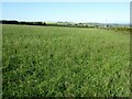
Farmland near Synod Inn
Farmland to the south of Synod Inn.
Image: © Philip Halling
Taken: 16 Jul 2021
0.16 miles