IMAGES TAKEN NEAR TO
Pencaerfenni Park, SWANSEA, SA4 3SQ
Introduction
This page details the photographs taken nearby to Pencaerfenni Park, SA4 3SQ by members of the Geograph project.
The Geograph project started in 2005 with the aim of publishing, organising and preserving representative images for every square kilometre of Great Britain, Ireland and the Isle of Man.

There are currently over 7.5m images from over14,400 individuals and you can help contribute to the project by visiting https://www.geograph.org.uk
Image Map (Loading...)


Getting Data...Please wait
Leaflet Map data © OpenStreetMap
Images are licensed for reuse under creativecommons.org/licenses/by-sa/2.0
Notes
- Clicking on the map will re-center to the selected point.
- The higher the marker number, the further away the image location is from the centre of the postcode.
Image Listing (15 Images Found)
Images are licensed for reuse under creativecommons.org/licenses/by-sa/2.0
Image
Details
Distance
1
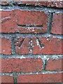
Ordnance Survey Cut Mark
This OS cut mark can be found on the gatepost of No22 Pencaerfenni Lane. It marks a point 7.605m above mean sea level.
Image: © Adrian Dust
Taken: 17 Dec 2015
0.09 miles
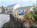
2
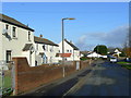
Main Street, Crofty
A village and small port on the north Gower coast.
Image: © Jonathan Billinger
Taken: 12 Nov 2008
0.10 miles
3

Crofty village street
This was once a small port for local coal mining on the south side of the Loughor estuary.
Image: © Jonathan Billinger
Taken: 12 Nov 2008
0.12 miles
4
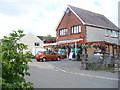
Crofty Post Office
Modern brick building with post office and shop in a village which is mainly of local stone houses in its central area.
Image: © Colin Smith
Taken: 24 Jul 2009
0.16 miles
5

Ordnance Survey Cut Mark
This damaged OS cut mark can be found on the gatepost of Burry House. It marks a point 13.795m above mean sea level.
Image: © Adrian Dust
Taken: 11 Feb 2022
0.17 miles

7

Zoar Chapel In Crofty
In the aptly named Chapel Road
Image: © Deborah Tilley
Taken: 6 Jun 2015
0.17 miles
8

Crofty Inn
Traditional style, family run village pub, located in the heart of Crofty village in the north of the Gower peninsula.
Image: © Alan Hughes
Taken: 23 Jul 2018
0.18 miles
9
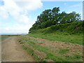
Welsh Coast Path going round Salthouse Point
Image: © Eirian Evans
Taken: 21 May 2022
0.18 miles
10
Crofty Inn
Village pub in Crofty, on the edge of the Llanrhidian salt marshes on the Loughor Estuary.
Image: © Colin Smith
Taken: 24 Jul 2009
0.19 miles