IMAGES TAKEN NEAR TO
Briscwm, CARDIGAN, SA43 3DW
Introduction
This page details the photographs taken nearby to Briscwm, SA43 3DW by members of the Geograph project.
The Geograph project started in 2005 with the aim of publishing, organising and preserving representative images for every square kilometre of Great Britain, Ireland and the Isle of Man.

There are currently over 7.5m images from over14,400 individuals and you can help contribute to the project by visiting https://www.geograph.org.uk
Image Map
Images are licensed for reuse under creativecommons.org/licenses/by-sa/2.0
Notes
- Clicking on the map will re-center to the selected point.
- The higher the marker number, the further away the image location is from the centre of the postcode.
Image Listing (14 Images Found)
Images are licensed for reuse under creativecommons.org/licenses/by-sa/2.0
Image
Details
Distance
1
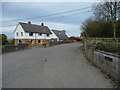
Briscwm farm house
A very smart and properous looking operation.
Image: © Jeremy Bolwell
Taken: 2 Nov 2011
0.05 miles
2
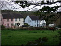
Briscwm
A small settlement between Llandudoch/St Dogmael's and the S487 southwest of Aberteifi/Cardigan.
Image: © Natasha Ceridwen de Chroustchoff
Taken: 1 May 2010
0.09 miles
3
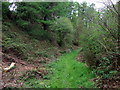
Footpath from Briscwm
It leads through this wooded valley and across fields to the lane called Mwtshwr in Llandudoch/St Dogmael's.
Image: © Natasha Ceridwen de Chroustchoff
Taken: 1 May 2010
0.10 miles
4
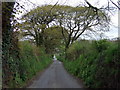
Lane into Briscwm
A turning off the A487 by Parc-y-pratt leads to the hamlet of Briscwm on the way to Llandudoch/St Dogmael's. Officially this is called Longtown Street.
Image: © Natasha Ceridwen de Chroustchoff
Taken: 1 May 2010
0.13 miles
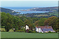
5
Panorama of Cardigan Bay
Taken from a gateway at the side of the A487, Cardigan town right of centre, St Dogmaels centre, Poppit sands and Cardigan Bay left of centre with Gwbert above.
Image: © Shaun Butler
Taken: 14 Oct 2007
0.15 miles
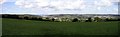
6
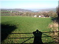
To Cardigan town
Views across the fields of Parc y pratt and Briscwm.
Image: © Deborah Tilley
Taken: 14 Feb 2010
0.17 miles
7
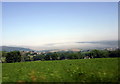
Mist rolling up the Teifi estuary
Photo taken from a moving vehicle (the bus!) to capture the spectacle of thick summer mist rolling in up the river towards Llandudoch/St Dogmaels (left) and Aberteifi/Cardigan town (right).
See Image for contrasting weather conditions.
Image: © Natasha Ceridwen de Chroustchoff
Taken: 31 May 2008
0.18 miles
8
View north towards the estuary of the Afon Teifi
The River Teifi (Afon Teifi) has a total length of 73 miles (117 km). It forms the boundary for most of its length between the counties of Ceredigion and Carmarthenshire, and for the final 3 miles (4.8 km), the boundary between Ceredigion and Pembrokeshire. It flows into Cardigan Bay at the town of Cardigan (Aberteifi).
Image: © Mat Fascione
Taken: 3 Jun 2019
0.19 miles
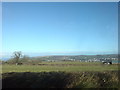
9
A clear sky over the Teifi estuary
This image was taken on a fine winter's day looking north towards the mouth of Afon Teifi. Llandudoch/St Dogmaels is the village on the western bank.
Contrast weather conditions with Image
Image: © Natasha Ceridwen de Chroustchoff
Taken: 3 Feb 2007
0.19 miles
10
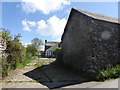
Parc-y-Pratt
Old farm buildings, there has been a settlement here since the 13th century
Image: © Eirian Evans
Taken: 20 May 2015
0.20 miles