IMAGES TAKEN NEAR TO
CARDIGAN, SA43 2LD
Introduction
This page details the photographs taken nearby to SA43 2LD by members of the Geograph project.
The Geograph project started in 2005 with the aim of publishing, organising and preserving representative images for every square kilometre of Great Britain, Ireland and the Isle of Man.

There are currently over 7.5m images from over14,400 individuals and you can help contribute to the project by visiting https://www.geograph.org.uk
Image Map (Loading...)


Getting Data...Please wait
Leaflet Map data © OpenStreetMap
Images are licensed for reuse under creativecommons.org/licenses/by-sa/2.0
Notes
- Clicking on the map will re-center to the selected point.
- The higher the marker number, the further away the image location is from the centre of the postcode.
Image Listing (6 Images Found)
Images are licensed for reuse under creativecommons.org/licenses/by-sa/2.0
Image
Details
Distance
1
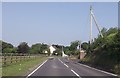
Y-Dorlan entrance from A484
Entrance on the left
Image: © John Firth
Taken: 10 Jul 2013
0.02 miles
2
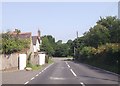
A484 passing the Equine Vets Clinic
Just prior to B4570 junction ahead
Image: © John Firth
Taken: 10 Jul 2013
0.07 miles
3
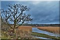
Teifi Marsh
Banc-y-Warren Crugmore, high point, in the distance.
This rather strange conical hill had a defended enclosure built on it in the Iron Age. The battle of Crug Mawr was fought in the vicinity in 1136 (Welsh 1, Normans 0). It seems to be the location for the following story:
Crug Mawr, or Pen tychryd Mawr, is a mountain, or lofty hill, in Cardiganshire, situated in the vale of Ayeron, mentioned in Giraldus, where, he says,
"there is an open grave, which fits the length of any man lying in it, short or long."
Hence rose the ancient tradition, that a powerful cawr, or giant, kept his post on this hill, who was endowed with the genius of the Ayeron vale. He had a lofty palace erected on the hill, and used occasionally to invite the neighbouring giants to a trial of strength on the top of it; at one of these meetings coits were proposed and introduced, and, after great efforts, the inhabitant of the spot won the day, by throwing his quoit clear into the Irish shore, which ever after gave him the superiority over all other giants in Caredig land.
He then proceeds to explain the stories away in a manner that completely misses the point that they are stories, invoking mistranslations and concealed machinery. Tch.
From 'The Cambrian Popular Antiquities' by Peter Roberts, 1815.
http://www.archive.org/stream/cambrianpopular00robegoog#page/n238/
Image: © Deborah Tilley
Taken: 31 Jan 2016
0.14 miles
4
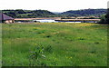
Teifi river and marshes
Looking southwest from the A484 towards the Afon Teifi with the marshes and reed beds beyond.
Image: © Natasha Ceridwen de Chroustchoff
Taken: 26 May 2007
0.18 miles
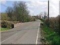
5
Pont Rhyd-y-fuwch, Llangoedmor
The North face of the North parapet used to bear an Ordnance Survey benchmark:
The mark was used on the Brecknock to Cardigan line of the First Primary Levelling of England & Wales in 1856. It was levelled with a height of 28.966' above OD (Liverpool). Description: 121. Mark on East pier of small bridge, over stream crossing road ; 5.19 ft. below top of parapet. Page 572 of the abstract: https://www.bench-marks.org.uk/abstract/ew1gl/1GLA_572.png
The mark was replaced by a BM on the South face at the West end of the parapet by 1904.
From the West: Image
Image: © N Scott
Taken: 22 Mar 2023
0.20 miles
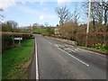
6
Pont Rhyd-y-fuwch, Llangoedmor
The North face of the North parapet used to bear an Ordnance Survey benchmark:
The mark was used on the Brecknock to Cardigan line of the First Primary Levelling of England & Wales in 1856. It was levelled with a height of 28.966' above OD (Liverpool). Description: 121. Mark on East pier of small bridge, over stream crossing road ; 5.19 ft. below top of parapet. Page 572 of the abstract: https://www.bench-marks.org.uk/abstract/ew1gl/1GLA_572.png
The mark was replaced by a BM on the South face at the West end of the parapet by 1904.
From the East: Image
Image: © N Scott
Taken: 22 Mar 2023
0.20 miles