IMAGES TAKEN NEAR TO
Harleyford Road, SWANSEA, SA4 0UR
Introduction
This page details the photographs taken nearby to Harleyford Road, SA4 0UR by members of the Geograph project.
The Geograph project started in 2005 with the aim of publishing, organising and preserving representative images for every square kilometre of Great Britain, Ireland and the Isle of Man.

There are currently over 7.5m images from over14,400 individuals and you can help contribute to the project by visiting https://www.geograph.org.uk
Image Map
Images are licensed for reuse under creativecommons.org/licenses/by-sa/2.0
Notes
- Clicking on the map will re-center to the selected point.
- The higher the marker number, the further away the image location is from the centre of the postcode.
Image Listing (19 Images Found)
Images are licensed for reuse under creativecommons.org/licenses/by-sa/2.0
Image
Details
Distance
1
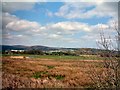
Loughor Valley
The valley of the Afon Loughor.
Image: © Gerald England
Taken: 29 Apr 2006
0.15 miles
2
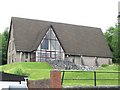
St David's Church, Hendy
This distinctive church is on the north side of the road on the eastern edge of Hendy, just before Pontardulais.
Image: © Nigel Davies
Taken: 20 May 2006
0.17 miles
3
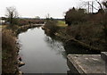
River Loughor towards the Dulais confluence in Pontarddulais
Viewed from Loughor Bridge. Distant white water shows where the Dulais flows into the River Loughor.
The midpoint of the Loughor here marks the boundary of the City and County of Swansea (formerly the county of Glamorgan) on the left and Carmarthenshire on the right.
Image: © Jaggery
Taken: 11 Feb 2015
0.20 miles
4
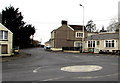
Iscoed Road, Hendy
The A4138 Iscoed Road heads SW away from the mini-roundabout at the A48 junction.
Hendy is at the eastern edge of Carmarthenshire. Viewed from the west bank of the Loughor,
the river which here marks the boundary of Carmarthenshire and the City & County of Swansea.
Image: © Jaggery
Taken: 11 Feb 2015
0.20 miles
5
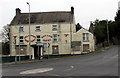
Derelict first view of Carmarthenshire
On crossing Loughor Bridge over the River Loughor, the visitor from Pontarddulais in the City and County of Swansea sees the Welcome to Carmarthenshire sign and the boarded-up former Red Lion Hotel.
Image: © Jaggery
Taken: 11 Feb 2015
0.21 miles
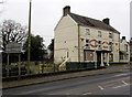
6
Derelict and boarded-up Red Lion Hotel, Hendy
Viewed across the A48 in February 2015.
Image: © Jaggery
Taken: 11 Feb 2015
0.21 miles
7
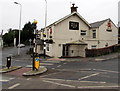
Zebra crossing to the Black Horse Inn in Hendy near Pontarddulais
The Black Horse is in the village of Hendy on the Carmarthenshire side of the River Loughor,
near the western boundary of Pontarddulais and the City and County of Swansea.
Image: © Jaggery
Taken: 11 Feb 2015
0.22 miles
8
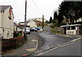
Clayton Road, Hendy
Clayton Road ascends from the A48 Fforest Road junction.
Hendy is part of the community of Llanedi, Carmarthenshire.
The Black Horse Inn http://www.geograph.org.uk/photo/4372680 is on the left.
Image: © Jaggery
Taken: 11 Feb 2015
0.22 miles
9

Direction signs outside the Black Horse Inn, Hendy
Left for the A4138 towards the centre of Hendy, the M4 (junction 48) and Llanelli.
Right for the A48 towards Fforest and Carmarthen. Turn right also for Llandeilo.
Image: © Jaggery
Taken: 11 Feb 2015
0.22 miles
10
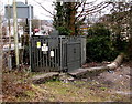
DANGER 11,000 VOLTS, Hendy, Carmarthenshire
The DANGER notice http://www.geograph.org.uk/photo/4415703 is one of several on the Western Power Distribution electricity substation at the western edge of the bridge carrying the A48 over the River Loughor from Pontarddulais. The river here marks the boundary between Carmarthenshire and the City & County of Swansea. The grey back of the Welcome to Carmarthenshire sign http://www.geograph.org.uk/photo/4344967 is on the left.
Image: © Jaggery
Taken: 11 Feb 2015
0.22 miles