IMAGES TAKEN NEAR TO
Heol Morlais, SWANSEA, SA4 0FF
Introduction
This page details the photographs taken nearby to Heol Morlais, SA4 0FF by members of the Geograph project.
The Geograph project started in 2005 with the aim of publishing, organising and preserving representative images for every square kilometre of Great Britain, Ireland and the Isle of Man.

There are currently over 7.5m images from over14,400 individuals and you can help contribute to the project by visiting https://www.geograph.org.uk
Image Map
Images are licensed for reuse under creativecommons.org/licenses/by-sa/2.0
Notes
- Clicking on the map will re-center to the selected point.
- The higher the marker number, the further away the image location is from the centre of the postcode.
Image Listing (13 Images Found)
Images are licensed for reuse under creativecommons.org/licenses/by-sa/2.0
Image
Details
Distance
1
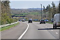
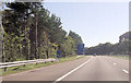
Carmarthenshire : M4 Motorway
The M4 Motorway heading eastbound through Carmarthenshire.
Image: © Lewis Clarke
Taken: 11 Apr 2014
0.06 miles
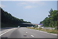
4
Junction with M4 motorway
Access to the motorway from the A4138.
Image: © Alan Hughes
Taken: 16 Oct 2019
0.17 miles
7
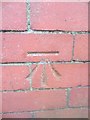
Ordnance Survey Cut Mark
This OS cut mark can be found on the brick pillar of No51 Heol Y Parc. It marks a point 13.56m above mean sea level.
Image: © Adrian Dust
Taken: 2 Mar 2014
0.18 miles
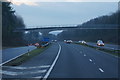
8
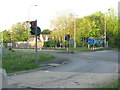
Leaving the M4 at J48
The junction with Pontardulais Road [A4138], left for Yr Hendy [Hendy] and right for Llanelli.
Image: © M J Richardson
Taken: 14 May 2016
0.19 miles
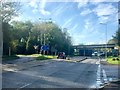
9
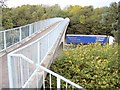
Footbridge over M4 at Hendy
This footbridge preserves an old right of way with the arrival of the motorway.
Image: © Nigel Davies
Taken: 27 Oct 2005
0.20 miles
10
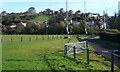
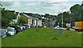
Rugby football ground, Hendy
Path by the ground which is on flat ground west of the river (Afon Gwili). Beyond the village is set on the hillside in the next square.
Image: © Andrew Hill
Taken: 22 Oct 2008
0.21 miles