IMAGES TAKEN NEAR TO
Maesycrugiau, PENCADER, SA39 9LJ
Introduction
This page details the photographs taken nearby to SA39 9LJ by members of the Geograph project.
The Geograph project started in 2005 with the aim of publishing, organising and preserving representative images for every square kilometre of Great Britain, Ireland and the Isle of Man.

There are currently over 7.5m images from over14,400 individuals and you can help contribute to the project by visiting https://www.geograph.org.uk
Image Map (3 Images)


Leaflet Map data © OpenStreetMap
Images are licensed for reuse under creativecommons.org/licenses/by-sa/2.0
Notes
- Clicking on the map will re-center to the selected point.
- The higher the marker number, the further away the image location is from the centre of the postcode.
Image Listing (3 Images Found)
Images are licensed for reuse under creativecommons.org/licenses/by-sa/2.0
Image
Details
Distance
2
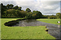
The River Teifi at Glanrhydypysgod
The steep bank is slowly eroding, sand martins nest here.
Image: © William Hester
Taken: 14 Sep 2004
0.16 miles
3
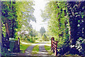
Site of former Maesycrugiau station, 2004
View southward near the village, towards Carmarthen on the track-bed of the ex-GWR Carmarthen - Aberystwyth line. The station was closed to passengers when the through service ceased 22/2/65, but goods continued until 9/9/65 and the line remained in place until 3/9/73 for the milk traffic all the way Carmarthen - Lampeter and onto the Aberayron branch as far as Felin Fach.
Image: © Ben Brooksbank
Taken: 25 Jun 2004
0.22 miles