IMAGES TAKEN NEAR TO
Llanpumsaint, CARMARTHEN, SA33 6BU
Introduction
This page details the photographs taken nearby to SA33 6BU by members of the Geograph project.
The Geograph project started in 2005 with the aim of publishing, organising and preserving representative images for every square kilometre of Great Britain, Ireland and the Isle of Man.

There are currently over 7.5m images from over14,400 individuals and you can help contribute to the project by visiting https://www.geograph.org.uk
Image Map
Images are licensed for reuse under creativecommons.org/licenses/by-sa/2.0
Notes
- Clicking on the map will re-center to the selected point.
- The higher the marker number, the further away the image location is from the centre of the postcode.
Image Listing (9 Images Found)
Images are licensed for reuse under creativecommons.org/licenses/by-sa/2.0
Image
Details
Distance
1
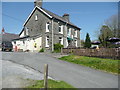
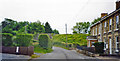
The Railway Inn, Clydtai, Llanpumsaint
Image: © Humphrey Bolton
Taken: 21 Apr 2019
0.13 miles
2
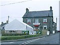
The Railway Inn, Llampumsaint
Named after the adjacent railway which is now dismantled and hasn't seen a passenger in 40 years. They do a very welcome decent cup of coffee for the cold and weary driver though. Inside there are a few old photos of the Aberystwyth terminus.
Image: © Nigel Davies
Taken: 1 Jan 2009
0.14 miles
3
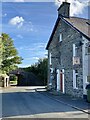
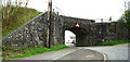
Railway Hotel
Hôtel adjacent to a disused railway line (note the bridge) near Llanpumsaint.
Image: © Alan Hughes
Taken: 29 Sep 2021
0.14 miles
4
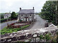
Railway Inn, Llanpumsaint
Tafarn y Railway o'r bont reilffordd. Caewyd y lein yn 1965.
The Railway Inn from the railway bridge. The line closed in 1965.
Image: © Alan Richards
Taken: 19 Aug 2023
0.14 miles
5
Railway Bridge
Disused railway bridge.
Image: © Dara Jasumani
Taken: 6 May 2006
0.14 miles
6
Site of Llanpumpsaint station, 2003
View NW to the embankment of the former railway, the station having been just off to the right: ex-GWR Aberystwyth - Carmarthen line, which was closed 22/2/65, following permanent blockage further north by floods on 14/12/64; goods (milk) continued however, Carmarthen - Lampeter - Felin Fach until 1/10/73.
Image: © Ben Brooksbank
Taken: 25 Jun 2003
0.15 miles
7
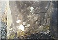
Ordnance Survey Cut Mark
This OS cut mark can be found on the NE buttress of the Railway Bridge. It marks a point 92.125m above mean sea level.
Image: © Adrian Dust
Taken: 24 Oct 2019
0.16 miles
8
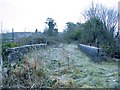
Atop the railway bridge in Llanpumsaint
This line definitely isn't being kept alive by dog walkers or cyclists. Only the relatively shallow soil on the bridge surface itself is protecting it from being choked by bushes as has happened at either end.
Image: © Nigel Davies
Taken: 1 Jan 2009
0.16 miles
9
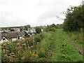
Hen reilffordd / Former railway
Dyma hen lein Caerfyrddin i Aberystwyth a gaewyd dan bwyell anenwog Beeching yn 1965 - twpdra o'r radd flaenaf. Mae'r trac yn eiddo i Reilffordd Gwili a'r bwriad yw ei hehangu i Lanpumsaint.
This is the former Carmarthen-Aberystwyth line which closed in 1965 by the infamous Beeching axe - an act of utter stupidity! The line belongs to the Gwili Railway and it hopes to extend the line to Llanpumsaint in the future.
Image: © Alan Richards
Taken: 19 Aug 2023
0.20 miles