IMAGES TAKEN NEAR TO
Pennard Drive, SWANSEA, SA3 2DN
Introduction
This page details the photographs taken nearby to Pennard Drive, SA3 2DN by members of the Geograph project.
The Geograph project started in 2005 with the aim of publishing, organising and preserving representative images for every square kilometre of Great Britain, Ireland and the Isle of Man.

There are currently over 7.5m images from over14,400 individuals and you can help contribute to the project by visiting https://www.geograph.org.uk
Image Map
Images are licensed for reuse under creativecommons.org/licenses/by-sa/2.0
Notes
- Clicking on the map will re-center to the selected point.
- The higher the marker number, the further away the image location is from the centre of the postcode.
Image Listing (4 Images Found)
Images are licensed for reuse under creativecommons.org/licenses/by-sa/2.0
Image
Details
Distance
1
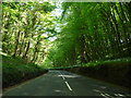
Garlic scented woods near Parkmill
This part of Kilvrough Manor Woods in May are strongly scented with wild garlic - it's like entering the kitchen of an upmarket Italian restaurant, except that the air is cool, as if it is air conditioned.
Image: © Jeremy Bolwell
Taken: 22 May 2012
0.22 miles
2
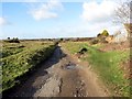
Hen Heol Pennard Old Road
Hen heol ddiwyneb yn mynd o Bennard i gyfeiriad Parkmill.
Old unsurfaced road heading in the direction of Parkmill.
Image: © Alan Richards
Taken: 24 Jan 2015
0.23 miles
3
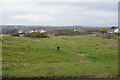
Path on the edge of Pennard Burrows
Now also on the edge of Southgate, where housing has been spreading.
Image: © Bill Boaden
Taken: 4 Apr 2016
0.24 miles
4
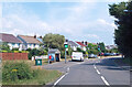
Pennard Road, Southgate
Speed monitor by the bus shelter.
Southgate is a mostly 20th century village.
Image: © Des Blenkinsopp
Taken: 23 Jul 2021
0.24 miles