IMAGES TAKEN NEAR TO
Priory Street, CARMARTHEN, SA31 1NZ
Introduction
This page details the photographs taken nearby to Priory Street, SA31 1NZ by members of the Geograph project.
The Geograph project started in 2005 with the aim of publishing, organising and preserving representative images for every square kilometre of Great Britain, Ireland and the Isle of Man.

There are currently over 7.5m images from over14,400 individuals and you can help contribute to the project by visiting https://www.geograph.org.uk
Image Map
Images are licensed for reuse under creativecommons.org/licenses/by-sa/2.0
Notes
- Clicking on the map will re-center to the selected point.
- The higher the marker number, the further away the image location is from the centre of the postcode.
Image Listing (84 Images Found)
Images are licensed for reuse under creativecommons.org/licenses/by-sa/2.0
Image
Details
Distance
1
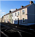
Oak Terrace houses, Carmarthen
On the north side of the A484. SAFLE BWS is Welsh for BUS STOP.
Image: © Jaggery
Taken: 18 Nov 2019
0.02 miles
2
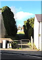
Metal barriers across a path on the north side of the A484, Carmarthen
The barriers prevent vehicular misuse of the path to Park Hall.
Image: © Jaggery
Taken: 18 Nov 2019
0.02 miles
3
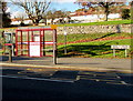
Bus stop, shelter and phonebox, Priory Street, Carmarthen
The sign on the right shows that Priory Street is Heol y Prior in Welsh.
Image: © Jaggery
Taken: 18 Nov 2019
0.02 miles
4
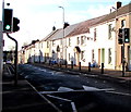
Pelican crossing on a hump across the A484, Carmarthen
Chambers Dictionary states that pelican in this context is adapted from pedestrian light controlled crossing.
Image: © Jaggery
Taken: 18 Nov 2019
0.03 miles
5
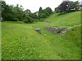
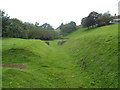
Roman amphitheatre, Carmarthen
Carmarthen's Roman amphitheatre was excavated in 1968 and 1970 and is an elliptical shape, approximately 90 metres by 60 metres. It is thought to date from around 75AD. The town of Carmarthen was known as 'Moridunum' by the Romans. It is one of two such visible amphitheatres in Wales, the other is at Caerleon.
Image: © Philip Halling
Taken: 16 Jun 2021
0.03 miles
6
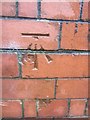
Ordnance Survey Cut Mark
This OS cut mark can be found on a brick post in the lane at the side of No51 Priory Street. It marks a point 23.530m above mean sea level.
Image: © Adrian Dust
Taken: 25 Jan 2014
0.03 miles
7
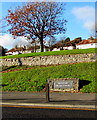
Amphitheatre Moridvnvm name sign, Carmarthen
Alongside Priory Street below these https://www.geograph.org.uk/photo/3083041 remains of an ancient Roman amphitheatre which was part of Moridvnvm (or Moridunum), Latin for sea fort, the ancient Roman fort and town in the Roman province of Britannia.
Image: © Jaggery
Taken: 18 Nov 2019
0.03 miles
8
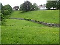
Roman amphitheatre
Remains of the Roman amphitheatre at Carmarthen.
Image: © Alan Hughes
Taken: 27 Feb 2020
0.03 miles
9
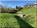
Remains of a Roman amphitheatre, Carmarthen
Excavated in 1968, this is one of only seven surviving Roman amphitheatres in the UK. It is located on the north side of the A484, here named Priory Street. The amphitheatre was part of Moridunum (Latin for sea fort), the ancient Roman fort and town in the Roman province of Britannia.
After the Roman era, Moridunum was known as Caerfyrddin. Fyrddin is a Welsh mutated form of Myrddin, which looks like a Welsh form of the Latin name. Caerfyrddin was later anglicised to Carmarthen. Caerfyrddin may have been misinterpreted as "Fort of Myrddin", hence the town's association with the Arthurian Merlin.
Image: © Jaggery
Taken: 12 Aug 2012
0.04 miles
10
Roman amphitheatre, Carmarthen
Carmarthen's Roman amphitheatre was excavated in 1968 and 1970 and is an elliptical shape, approximately 90 metres by 60 metres. It is thought to date from around 75AD. The town of Carmarthen was known as 'Moridunum' by the Romans. It is one of two such visible amphitheatres in Wales, the other is at Caerleon.
Image: © Philip Halling
Taken: 16 Jun 2021
0.04 miles