IMAGES TAKEN NEAR TO
Ropewalk, Priory Street, CARMARTHEN, SA31 1NW
Introduction
This page details the photographs taken nearby to Ropewalk, Priory Street, SA31 1NW by members of the Geograph project.
The Geograph project started in 2005 with the aim of publishing, organising and preserving representative images for every square kilometre of Great Britain, Ireland and the Isle of Man.

There are currently over 7.5m images from over14,400 individuals and you can help contribute to the project by visiting https://www.geograph.org.uk
Image Map (Loading...)


Getting Data...Please wait
Leaflet Map data © OpenStreetMap
Images are licensed for reuse under creativecommons.org/licenses/by-sa/2.0
Notes
- Clicking on the map will re-center to the selected point.
- The higher the marker number, the further away the image location is from the centre of the postcode.
Image Listing (82 Images Found)
Images are licensed for reuse under creativecommons.org/licenses/by-sa/2.0
Image
Details
Distance
1
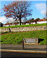
Amphitheatre Moridvnvm name sign, Carmarthen
Alongside Priory Street below these https://www.geograph.org.uk/photo/3083041 remains of an ancient Roman amphitheatre which was part of Moridvnvm (or Moridunum), Latin for sea fort, the ancient Roman fort and town in the Roman province of Britannia.
Image: © Jaggery
Taken: 18 Nov 2019
0.02 miles
2
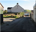
Furnace Bank, Carmarthen
Dead-end road on the southeast side of the A484 Abbey Mead opposite Priory Close.
Image: © Jaggery
Taken: 18 Nov 2019
0.02 miles
3
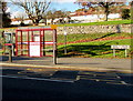
Bus stop, shelter and phonebox, Priory Street, Carmarthen
The sign on the right shows that Priory Street is Heol y Prior in Welsh.
Image: © Jaggery
Taken: 18 Nov 2019
0.03 miles
4
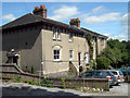
The old Grammar School at Carmarthen
Now used as housing
Image: © John Duckfield
Taken: 13 Aug 2009
0.03 miles
5
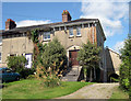
The old Grammar School at Carmarthen
Now used as housing.
Image: © John Duckfield
Taken: 13 Aug 2009
0.03 miles
6
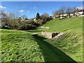
Roman amphitheatre
Remains of the Roman amphitheatre at Carmarthen.
Image: © Alan Hughes
Taken: 27 Feb 2020
0.04 miles
7
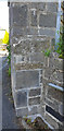
Off Priory Close, Carmarthen
This was the entrance to Milestone House, now a private drive to a group of modern houses. In 1906 the house was called Furnace Lodge. One stone is carved with the name "Milestone" (this is not a milestone).
Image: © Kirstie Hackett
Taken: 19 Jul 2020
0.04 miles
8
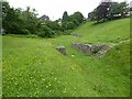
Roman amphitheatre, Carmarthen
Carmarthen's Roman amphitheatre was excavated in 1968 and 1970 and is an elliptical shape, approximately 90 metres by 60 metres. It is thought to date from around 75AD. The town of Carmarthen was known as 'Moridunum' by the Romans. It is one of two such visible amphitheatres in Wales, the other is at Caerleon.
Image: © Philip Halling
Taken: 16 Jun 2021
0.04 miles
9
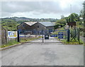
No bank holiday opening at Jewson, Carmarthen
It's early afternoon on Spring Bank Holiday (Monday May 30th 2011) but the entrance gates to the Jewson site are locked. The builders' merchants site is located in The Old Tin Works between Abbey Mead (A484) and the A40. The entrance is from the A484.
Image: © Jaggery
Taken: 30 May 2011
0.04 miles
10
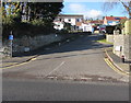
Up Priory Close, Carmarthen
Priory Close (Garth y Prior in Welsh) ascends from the A484 Abbey Mead.
Image: © Jaggery
Taken: 18 Nov 2019
0.05 miles