IMAGES TAKEN NEAR TO
Little Water Street, CARMARTHEN, SA31 1ER
Introduction
This page details the photographs taken nearby to Little Water Street, SA31 1ER by members of the Geograph project.
The Geograph project started in 2005 with the aim of publishing, organising and preserving representative images for every square kilometre of Great Britain, Ireland and the Isle of Man.

There are currently over 7.5m images from over14,400 individuals and you can help contribute to the project by visiting https://www.geograph.org.uk
Image Map
Images are licensed for reuse under creativecommons.org/licenses/by-sa/2.0
Notes
- Clicking on the map will re-center to the selected point.
- The higher the marker number, the further away the image location is from the centre of the postcode.
Image Listing (437 Images Found)
Images are licensed for reuse under creativecommons.org/licenses/by-sa/2.0
Image
Details
Distance
1
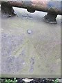
Ordnance Survey Rivet
This OS Rivet can be found on the wall with railings to the NW angle of No54 Little Water Street. It marks a point 18.810m above mean sea level.
Image: © Adrian Dust
Taken: 1 Mar 2014
0.03 miles
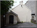
2
Back of building next to King Street Car Park
One of the less scenic parts of Carmarthen.
This is the back of the building in Image
Image: © Jeff Gogarty
Taken: 15 May 2015
0.04 miles
3
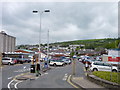
King's Street Car Park, Carmarthen
Radio masts on Penlan Hill can be seen in the distance
Image: © Jeff Gogarty
Taken: 15 May 2015
0.05 miles
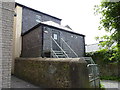
4
Formerly a doctor's surgery
Down an alley off King Street next to the Library Carmarthen
Image: © Jeff Gogarty
Taken: 15 May 2015
0.05 miles
5
Location of OS Pivot - Carmarthen, Notts Square Monument
Image: © thejackrustles
Taken: 9 Oct 2022
0.05 miles
6
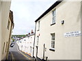
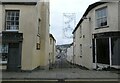
Little Water Street, Carmarthen
Taken from King Street.
Image: © Jeff Gogarty
Taken: 15 May 2015
0.05 miles
7
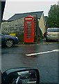
Ciosg Coch Telegyfathrebu Phrydeinig - - - British Telecommunication's red kiosk
Telegyfathrebu tynnwyd yn y maes parcio; oddi ar Stryd Sant Pedr
- - - - -
Telecommunications taken at the car park just off Saint Peter's street
Image: © G Williams
Taken: 27 Nov 2008
0.05 miles
8
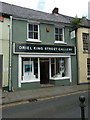
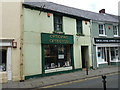
33, King Street, Carmarthen
One of a series of Grade II listed buildings along King Street, this one having a joint listing with 34 next door on its left https://www.britishlistedbuildings.co.uk/300009466-nos33-34-king-streetdyfed-carmarthen#.WUDcAusrKM8 The property dates in its present form from the 18th century, and has been much altered since then; one of the most interesting features is the 10-foot thick dividing wall in the cellar between this and no 34, which is believed to be a piece of the original early 15th century medieval town walls.
Image: © Richard Law
Taken: 30 May 2017
0.05 miles
9
Little Water Street
Off King Street.
Image: © Gerald England
Taken: 17 Oct 2021
0.06 miles
10
34, King Street, Carmarthen
Formerly the Cresselly Arms public house on King Street, and now a commercial property, which dates substantially from the 18th century. The building was given a Grade II listing https://www.britishlistedbuildings.co.uk/300082122-34king-streetsa31-1bs-carmarthen#.WUDaTesrKM8 in 1981, and incorporates a large chunk of the medieval town wall within its cellars.
Image: © Richard Law
Taken: 30 May 2017
0.06 miles