IMAGES TAKEN NEAR TO
Voylart Close, SWANSEA, SA2 7TZ
Introduction
This page details the photographs taken nearby to Voylart Close, SA2 7TZ by members of the Geograph project.
The Geograph project started in 2005 with the aim of publishing, organising and preserving representative images for every square kilometre of Great Britain, Ireland and the Isle of Man.

There are currently over 7.5m images from over14,400 individuals and you can help contribute to the project by visiting https://www.geograph.org.uk
Image Map
Images are licensed for reuse under creativecommons.org/licenses/by-sa/2.0
Notes
- Clicking on the map will re-center to the selected point.
- The higher the marker number, the further away the image location is from the centre of the postcode.
Image Listing (25 Images Found)
Images are licensed for reuse under creativecommons.org/licenses/by-sa/2.0
Image
Details
Distance
2
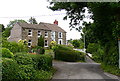
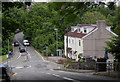
Voylart Road, Dunvant
The speed hump hardly seems necessary on this narrow and sinuous lane!
Image: © john bristow
Taken: 28 Jun 2013
0.07 miles
3
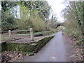
Llwybr Beicio Dyfnant/ Dunvant Cycle Path
Llwybr troed yn gadael y ffordd seiclo ger hen Orsaf Reilfordd y Dyfnant. Caewyd y lein yn 1964 gan fwyell Beeching.
A footpath leaving the cycle path near Dunvant < Dyfnant (trans deep valley) near the former Dunvant Railway Station. The line closed in 1964 by the now infamous Beeching Axe.
Image: © Alan Richards
Taken: 5 Jan 2015
0.12 miles
5
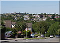
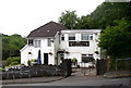
West Dunvant, from Dunvant Hill
The cars coming towards the camera have just climbed the 1 in 5 gradient from the centre of the village. Buildings in the village of Three Crosses can be seen on the skyline to the left of the picture.
Image: © john bristow
Taken: 24 Jul 2012
0.14 miles
6
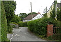
Killan Road descends towards junction with Walter's Row
Image: © Stuart Logan
Taken: 23 Apr 2014
0.14 miles
7
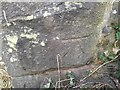
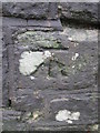
Ordnance Survey Cut Mark
This OS cut mark can be found on the SE buttress of the railway bridge. It marks a point 175.4ft above mean sea level.
Image: © Adrian Dust
Taken: 15 Feb 2023
0.15 miles
9
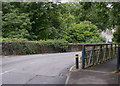
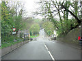
Dunvant Bridge
This bridge carries the B4296 road over the Clyne Trail, formally a railway closed in 1964. The bridge experiences fairly regular collisions due to its sinuous alignment and its location at the bottom of a steep hill.
Image: © john bristow
Taken: 8 Aug 2012
0.15 miles
10
Ordnance Survey Cut Mark
This OS cut mark can be found on the NE parapet of the railway bridge. It marks a point 59.612m above mean sea level.
Image: © Adrian Dust
Taken: 13 Dec 2015
0.15 miles