IMAGES TAKEN NEAR TO
Dan Y Crug, LLANDOVERY, SA20 0RB
Introduction
This page details the photographs taken nearby to Dan Y Crug, SA20 0RB by members of the Geograph project.
The Geograph project started in 2005 with the aim of publishing, organising and preserving representative images for every square kilometre of Great Britain, Ireland and the Isle of Man.

There are currently over 7.5m images from over14,400 individuals and you can help contribute to the project by visiting https://www.geograph.org.uk
Image Map
Images are licensed for reuse under creativecommons.org/licenses/by-sa/2.0
Notes
- Clicking on the map will re-center to the selected point.
- The higher the marker number, the further away the image location is from the centre of the postcode.
Image Listing (49 Images Found)
Images are licensed for reuse under creativecommons.org/licenses/by-sa/2.0
Image
Details
Distance
1
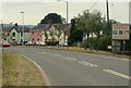
Eastern boundary of Llandovery
Brecon Road (the A40) reaches the small market town of Llandovery in eastern Carmarthenshire. Llandovery's population on the day of the 2001 Census was 2,870.
Image: © Jaggery
Taken: 5 Jun 2011
0.01 miles
2
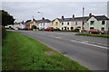
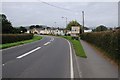
Houses on Brecon Road
Houses on Brecon Road, the A40, the first houses passed when entering Llandovery from the east.
Image: © Philip Halling
Taken: 20 Sep 2015
0.02 miles
3
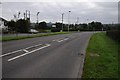
The A40, Brecon Road
The A40, Brecon Road leaving Llandovery to the east of the town.
Image: © Philip Halling
Taken: 20 Sep 2015
0.03 miles
4
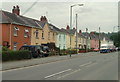
Colourful houses at the eastern edge of Llandovery
Dan y Crug is a row of 20 houses alongside Brecon Road (the A40).
Image: © Jaggery
Taken: 5 Jun 2011
0.04 miles
5
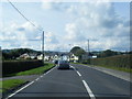
The A40 entering Llandovery
The A40, Brecon Road entering Llandovery.
Image: © Philip Halling
Taken: 20 Sep 2015
0.06 miles
7
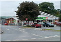
Co-operative Food store, Llandovery
Located on the north side of Brecon Road (the A40) at the eastern edge of Llandovery.
The store was formerly a Somerfield. http://www.geograph.org.uk/photo/987553
Image: © Jaggery
Taken: 5 Jun 2011
0.07 miles
8
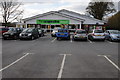
The Co-operative, Llandovery
This store on Beacon Road used to be Somerfield.
Image: © Philip Halling
Taken: 4 May 2013
0.07 miles
9
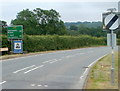
Distances from Llandovery
The sign at the edge of the A40 near the eastern boundary http://www.geograph.org.uk/photo/3186234 of Llandovery shows
that it is 20 miles to Brecon (Powys) and 40 miles to Abergavenny (Monmouthshire).
Image: © Jaggery
Taken: 5 Jun 2011
0.08 miles
10
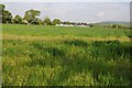
Wheat field beside Erwlon Campsite
Wheat field beside Erwlon Campsite viewed from a riverside dog walk from the campsite.
Image: © Philip Halling
Taken: 18 May 2014
0.09 miles