IMAGES TAKEN NEAR TO
Rhosmaen, LLANDEILO, SA19 6NS
Introduction
This page details the photographs taken nearby to SA19 6NS by members of the Geograph project.
The Geograph project started in 2005 with the aim of publishing, organising and preserving representative images for every square kilometre of Great Britain, Ireland and the Isle of Man.

There are currently over 7.5m images from over14,400 individuals and you can help contribute to the project by visiting https://www.geograph.org.uk
Image Map
Images are licensed for reuse under creativecommons.org/licenses/by-sa/2.0
Notes
- Clicking on the map will re-center to the selected point.
- The higher the marker number, the further away the image location is from the centre of the postcode.
Image Listing (6 Images Found)
Images are licensed for reuse under creativecommons.org/licenses/by-sa/2.0
Image
Details
Distance
1
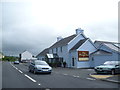
The Plough Inn, Rhosmaen, Carms
Another popular roadside restaurant and hostelry.
Image: © Jeremy Bolwell
Taken: 26 Jul 2015
0.05 miles
2
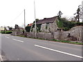
Melin Rhosmaen / Rhosmaen Mill
Yr hen felin adfeiliedig wrth ochr yr A40.
The ruined corn mill located alongside the A40.
Image: © Alan Richards
Taken: 23 Mar 2019
0.09 miles
4
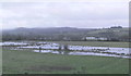
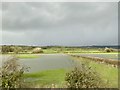
Flood plain
Just outside of Rhosmaen, the rail line is behind the line of hedging, and the Afon Tywi is beyond.
Image: © chris whitehouse
Taken: 2 Jan 2014
0.20 miles
5
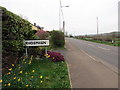
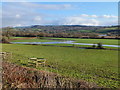
Pentre Rhosmaen Rhosmaen village
Yr A40 yn mynd drwy bentre Rhosmaen.
The A40 reaches the village of Rhosmaen (trans. marshland / plain of the stone).
Image: © Alan Richards
Taken: 23 Mar 2019
0.21 miles