IMAGES TAKEN NEAR TO
Maes Yr Helyg, AMMANFORD, SA18 2SX
Introduction
This page details the photographs taken nearby to Maes Yr Helyg, SA18 2SX by members of the Geograph project.
The Geograph project started in 2005 with the aim of publishing, organising and preserving representative images for every square kilometre of Great Britain, Ireland and the Isle of Man.

There are currently over 7.5m images from over14,400 individuals and you can help contribute to the project by visiting https://www.geograph.org.uk
Image Map
Images are licensed for reuse under creativecommons.org/licenses/by-sa/2.0
Notes
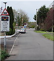
- Clicking on the map will re-center to the selected point.
- The higher the marker number, the further away the image location is from the centre of the postcode.
Image Listing (30 Images Found)
Images are licensed for reuse under creativecommons.org/licenses/by-sa/2.0
Image
Details
Distance
1
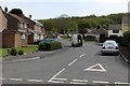
Heol Ceirios, Llandybie
Residential street on the east side of the A483 Ammanford Road.
Image: © Jaggery
Taken: 1 May 2015
0.07 miles
2
Green text on a street name sign in Llandybie
Most of the street name signs in Llandybie are of the style and colour http://www.geograph.org.uk/photo/4442848 typical in Carmarthenshire. In this part in the south of the village, I noticed several different style signs with green text, such as the one on the right, which shows the unusual street name (for a Welsh village) of McKays.
Image: © Jaggery
Taken: 1 May 2015
0.09 miles
3
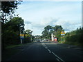
A483 northbound at Llandybie village boundary
Image: © Colin Pyle
Taken: 19 Sep 2015
0.10 miles
4
Tan y Lan, Llandybie
Cul-de-sac on the south side of Glynhir Road.
Image: © Jaggery
Taken: 1 May 2015
0.11 miles
5
STOP when lights show ahead, Llandybie
The sign is on the eastern approach to Brynmarlais Crossing http://www.geograph.org.uk/photo/4456045 across the Heart of Wales Line.
Image: © Jaggery
Taken: 1 May 2015
0.12 miles
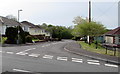
6
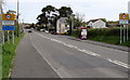
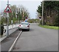
Southern boundary of Llandybie
The A483 north from Ammanford reaches the boundary sign for Llandybie, a large village in Carmarthenshire. The sign shows that Llandybie is twinned with Plonéour-Lanvern in Brittany. The speed limits drops from 40mph to 30mph.
Image: © Jaggery
Taken: 1 May 2015
0.13 miles
7
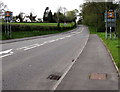
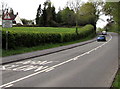
End of the 30mph speed limit in Llandybie
The speed limit on the A483 increases to 40mph.
The Llandybie southern boundary signs http://www.geograph.org.uk/photo/4457145 are on the back of the 40 signs.
Image: © Jaggery
Taken: 1 May 2015
0.13 miles
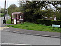
8
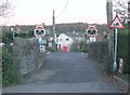
Level crossing and bridge over the Marlais
No matter how expensive the houses here, no one will own a stretch limo. This narrow single track road with tight corners crosses a bumpy railway and a hump backed bridge over the river Marlais.
Image: © Nigel Davies
Taken: 13 Nov 2005
0.13 miles
9
Risk of grounding sign, McKays, Llandybie
Alongside the street named McKays, the sign depicting an exaggerated mound beneath a grounded
vehicle warns of the possibility of long vehicles grounding on the level crossing ahead. http://www.geograph.org.uk/photo/4456045
Image: © Jaggery
Taken: 1 May 2015
0.14 miles
10
Blind summit warning sign south of Llandybie
Alongside the A483 Bonllwyn Road.
Image: © Jaggery
Taken: 1 May 2015
0.15 miles