IMAGES TAKEN NEAR TO
Pleasant View, KIDWELLY, SA17 4AL
Introduction
This page details the photographs taken nearby to Pleasant View, SA17 4AL by members of the Geograph project.
The Geograph project started in 2005 with the aim of publishing, organising and preserving representative images for every square kilometre of Great Britain, Ireland and the Isle of Man.

There are currently over 7.5m images from over14,400 individuals and you can help contribute to the project by visiting https://www.geograph.org.uk
Image Map (Loading...)


Getting Data...Please wait
Leaflet Map data © OpenStreetMap
Images are licensed for reuse under creativecommons.org/licenses/by-sa/2.0
Notes
- Clicking on the map will re-center to the selected point.
- The higher the marker number, the further away the image location is from the centre of the postcode.
Image Listing (12 Images Found)
Images are licensed for reuse under creativecommons.org/licenses/by-sa/2.0
Image
Details
Distance
1
Garden Suburbs, Trimsaran
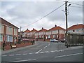
Viewed from Heol Llanelli. Carmarthenshire County Council has recently refurbished most of the 200 homes in Garden Suburbs. Externally, the houses have been re-pointed, insulated, re-rendered, re-roofed and had new double glazing installed. New garden walls and railings and off-road parking bays for some properties have also helped to smarten the estate. 60 of the 200 properties are council owned. Owners of the private properties had the refurbishment work heavily subsidised by the council.
Image: © Richard Dorrell
Taken: 15 Jun 2013
0.06 miles
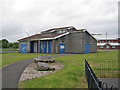
2
Gwynne Price Coaches depot
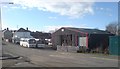
This is the depot and headquarters of Gwynne Price coaches in Trimsaran. A small stream goes under a bridge in the foreground.
Image: © Hywel Williams
Taken: 23 Jan 2007
0.11 miles
3
Post Office and shops, Trimsaran
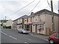
Along with the post office, the businesses here are an Indian take-away, a hair and beauty salon and a fish and chip bar. The shops stand on Heol Llanelli.
Image: © Richard Dorrell
Taken: 15 Jun 2013
0.13 miles
4
Cae Linda, Trimsaran
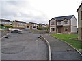
This entire development site of a cul-de-sac of seven detached houses (most not yet built) is currently for sale.
Image: © Richard Dorrell
Taken: 15 Jun 2013
0.14 miles
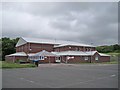
5
Trimsaran Miners Welfare Hall
The 1960s built hall is available for use by local community groups.
Image: © Richard Dorrell
Taken: 15 Jun 2013
0.16 miles
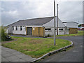
6
Sports pavilion, Trimsaran
In the background is the smart and modern Leisure Centre which opened in 2002, so the rather unloved-looking building photographed - which I am sure is a sports pavilion - may no longer be in use. No signs indicate a user or owner.
Image: © Richard Dorrell
Taken: 15 Jun 2013
0.18 miles
7
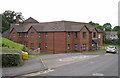
Llys y Godian, Trimsaran
Sheltered housing owned by Carmarthenshire County Council.
Image: © Richard Dorrell
Taken: 15 Jun 2013
0.18 miles
8
Trimsaran Leisure Centre
A modern facility offering a wide range of indoor and outdoor sports and leisure activities.
Image: © Richard Dorrell
Taken: 15 Jun 2013
0.19 miles
9
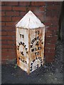
Old Milestone by the B4308, Heol Llanelli, Trimsaran
Carmarthen pyramid by the B4308, in parish of Trimsaran (Carmarthenshire District), Trimsaran, on Heol Llanelli, North east side of road.
Inscription reads:-
: TO / LLANELLY / 4 / MILES : : TO / KIDWELLY / 4 / MILES / TO / CARMARTHEN / 13 / (MILES) :
Grade II Listed by Cadw.
Reference Number 81326: https://cadwpublic-api.azurewebsites.net/reports/listedbuilding/FullReport?lang=&id=81326
Surveyed
Milestone Society National ID: CAM_CMLE13
Image: © Milestone Society
Taken: Unknown
0.20 miles
10
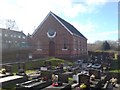
Noddfa Chapel, Trimsaran
One of the many non-conformist chapels that are found in this part of the country.
Image: © Hywel Williams
Taken: 23 Jan 2007
0.21 miles