IMAGES TAKEN NEAR TO
Norfolk Street, SWANSEA, SA1 6JB
Introduction
This page details the photographs taken nearby to Norfolk Street, SA1 6JB by members of the Geograph project.
The Geograph project started in 2005 with the aim of publishing, organising and preserving representative images for every square kilometre of Great Britain, Ireland and the Isle of Man.

There are currently over 7.5m images from over14,400 individuals and you can help contribute to the project by visiting https://www.geograph.org.uk
Image Map
Images are licensed for reuse under creativecommons.org/licenses/by-sa/2.0
Notes
- Clicking on the map will re-center to the selected point.
- The higher the marker number, the further away the image location is from the centre of the postcode.
Image Listing (94 Images Found)
Images are licensed for reuse under creativecommons.org/licenses/by-sa/2.0
Image
Details
Distance
1
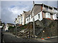
Collapse on Constitution Hill
The end of Cromwell Road fell away in July 2009 after a period of heavy rain.
Image: © Natasha Ceridwen de Chroustchoff
Taken: 21 Oct 2009
0.03 miles
2
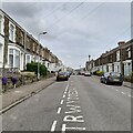
Rhondda Street
Just off the very steep Constitution Hill in Mount Pleasant.
Image: © Z Pryce
Taken: 7 Jun 2021
0.03 miles
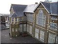
3

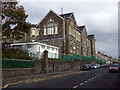
Terrace Road Primary School, Swansea
Viewed from Terrace Road looking down towards Norfolk Street. The following information, based on the school's website, shows that, most unusually, the capacity of the school was increased by building downwards.
Terrace Road Primary School was built in 1887 and opened its gates to 220 pupils on Monday August 27th 1888, with ample space to accommodate 360 more. However, by 1895 the school was becoming overcrowded with 600 pupils, so plans were put forward to extend the school by underpinning -
to excavate the original foundation and build a new lower hall and classrooms under the existing building. The extension provided space for a further 500 pupils. On July 7th 1897, in Queen Victoria's Diamond Jubilee year, a stone was unveiled to commemorate the enlargement of the school.
Image: © Jaggery
Taken: 27 Apr 2014
0.04 miles
4
Terrace Road Primary School
The school was built in 1888. http://www.archivesnetworkwales.info/cgi-bin/anw/fulldesc_nofr?inst_id=34&coll_id=77064&expand= Photo taken through railings in Terrace Road and above a tall stone retaining wall with its base in the playground below. There is an entrance to the school at this upper level.The corner of Norfolk Street and Harcourt Street can be seen to the left of the school and the sea is beyond the buildings in the distance.
Image: © Peter Shaw
Taken: 18 Dec 2008
0.04 miles
5
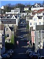
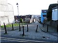
Constitution Hill
A steep cobbled hill leading from Walters Road to Terrace road. A funicular railway operated on the hill between 1898 and 1903 on a gradient of between 14% and 28.6%. The hill has often been used in a stage of the Round Britain cycle race. For a view from the top follow this http://www.geograph.org.uk/photo/1088271 .
Image: © Peter Shaw
Taken: 6 Dec 2008
0.04 miles
6

West along Norfolk Street, Swansea
From the corner of Harcourt Street.
Image: © Jaggery
Taken: 27 Apr 2014
0.04 miles
7
Terrace Road Primary School in Norfolk Street
Impressive Victorian school opened in 1888 to serve the growing population of this once-rural hillside. The school originally faced Terrace Road, above, but as numbers swelled it was extended downwards to provide more classrooms at a lower level here in Norfolk Street, with the result that the building has four storeys.
Image: © Natasha Ceridwen de Chroustchoff
Taken: 21 Oct 2009
0.05 miles
8
Constitution Hill
Stryd serth enwog goblog yn Abertawe o'r enw Constitution Hill. Yn 2010 bu raid i seiclwyr ei dringo yn y ras 'Tour of Britain'.
Constitution Hill - the famous steep cobbled street in Swansea. During the 2010 Tour of Britain competitors had to cycle up to the top.
Image: © Alan Richards
Taken: 16 Jan 2015
0.05 miles
9
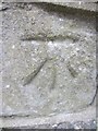
Ordnance Survey Cut Mark
This OS cut mark can be found on No5 Constitution Hill. It marks a point 64.145m above mean sea level.
Image: © Adrian Dust
Taken: 31 Oct 2013
0.05 miles
10
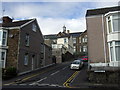
Rhondda Street, Mount Pleasant
Looking up Primrose Street towards Norfolk Street. The cupola marks Terrace Road Primary School.
Image: © Natasha Ceridwen de Chroustchoff
Taken: 21 Oct 2009
0.05 miles