IMAGES TAKEN NEAR TO
Parc Dyfatty Park, BURRY PORT, SA16 0FB
Introduction
This page details the photographs taken nearby to Parc Dyfatty Park, SA16 0FB by members of the Geograph project.
The Geograph project started in 2005 with the aim of publishing, organising and preserving representative images for every square kilometre of Great Britain, Ireland and the Isle of Man.

There are currently over 7.5m images from over14,400 individuals and you can help contribute to the project by visiting https://www.geograph.org.uk
Image Map
Images are licensed for reuse under creativecommons.org/licenses/by-sa/2.0
Notes
- Clicking on the map will re-center to the selected point.
- The higher the marker number, the further away the image location is from the centre of the postcode.
Image Listing (11 Images Found)
Images are licensed for reuse under creativecommons.org/licenses/by-sa/2.0
Image
Details
Distance
1
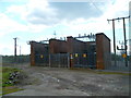
Electricity substation near Ashpits Pond, Burry Port
Located near a roundabout on the B4311.
Image: © Jaggery
Taken: 15 Apr 2012
0.11 miles
2
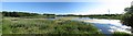
Ashpits Pond
A panoramic view of the west end of Ashpits Pond.
This pond was once part of the former Burry Port power station but is now a Local Nature Reserve.
Image: © Nigel Davies
Taken: 18 Jun 2017
0.13 miles
3
Burry Port lighthouse on a roundabout
The roundabout is on the A484 Llanelli to Carmarthen road
Image: © Eirian Evans
Taken: 22 May 2022
0.15 miles
4
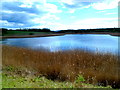
Ashpits Pond, Burry Port
Ashpits Pond used to be a settling lagoon for the former Carmarthen Bay Power Station.
It is now a Local Nature Reserve for breeding birds and many rare plants.
Image: © Jaggery
Taken: 15 Apr 2012
0.17 miles
5
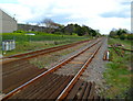
View east from Church Road level crossing, Burry Port
Looking east along the West Wales Line from this http://www.geograph.org.uk/photo/3604460 level crossing.
Image: © Jaggery
Taken: 15 Apr 2012
0.19 miles
6

East along the West Wales Line, Burry Port
Viewed from Church Road level crossing. Next station ahead is Llanelli on the route to Swansea.
Image: © Jaggery
Taken: 13 Mar 2018
0.19 miles
7
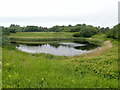
One of the ponds at Ashpits Pond Nature Reserve
Ashpits Pond is an important area for breeding wetland birds and the area of reed surrounding the pond provides shelter for breeding and resting birds. The ponds were formerly used as settling lagoons for pulverised fuel ash from the now demolished Carmarthen Bay Power Station
Image: © Eirian Evans
Taken: 22 May 2022
0.23 miles
8
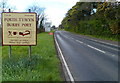
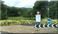
Eastern boundary of Burry Port
The A484 from Pwll reaches Burry Port, a small town on the Loughor estuary in Carmarthenshire.
The sign shows that Burry Port is Porth Tywyn in Welsh.
Image: © Jaggery
Taken: 15 Apr 2012
0.24 miles
9
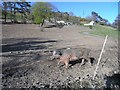
Pig in mud
Can you see the pig from the mud? I have no idea why the entire area where the pig wandered around (surrounded by electric fences) had no grass or any other greenery.
The hotel in the background also had a distinctly unused look about it - it looked like it had suffered from a major fire.
Image: © Hywel Williams
Taken: 6 Apr 2008
0.24 miles
10
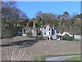
Burnt out hotel
Not a venue to book a holiday at any more, this sad looking structure burnt down not so long ago.
Image: © Hywel Williams
Taken: 6 Apr 2008
0.24 miles