IMAGES TAKEN NEAR TO
Heol Y Meinciau, LLANELLI, SA15 5TR
Introduction
This page details the photographs taken nearby to Heol Y Meinciau, SA15 5TR by members of the Geograph project.
The Geograph project started in 2005 with the aim of publishing, organising and preserving representative images for every square kilometre of Great Britain, Ireland and the Isle of Man.

There are currently over 7.5m images from over14,400 individuals and you can help contribute to the project by visiting https://www.geograph.org.uk
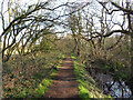
Image Map (Loading...)


Getting Data...Please wait
Leaflet Map data © OpenStreetMap
Images are licensed for reuse under creativecommons.org/licenses/by-sa/2.0
Notes
- Clicking on the map will re-center to the selected point.
- The higher the marker number, the further away the image location is from the centre of the postcode.
Image Listing (24 Images Found)
Images are licensed for reuse under creativecommons.org/licenses/by-sa/2.0
Image
Details
Distance
1
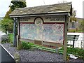
Board announcing Pontyates Mining Heritage Walk
The walk goes south west from Pontyates, across reclaimed land, which until fairly recently was an open cast coal mine http://www.sirgaerfyrddin.gov.uk/English/leisure/countryside/Walking/Documents/Pontiets%20Walks.pdf . The trail runs adjacent to a section of the disused Burry Port and Gwendraeth Valley Railway http://www.geograph.org.uk/photo/1403440 . The board is outside the garden of the Pontyates Welfare Hall.
Image: © Rose and Trev Clough
Taken: 14 Oct 2008
0.04 miles
2
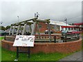
Sitting area in Pontyates
On Heol y Meinciau, opposite Image The information board describes the history of coal mining in the area. The timbers are a reconstruction of the props used down the mines.
Image: © Rose and Trev Clough
Taken: 14 Oct 2008
0.04 miles
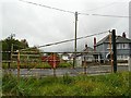
3

The Welfare Hall and War Memorial, Pont-iets
Image: © John Lord
Taken: 17 Oct 2008
0.04 miles
4
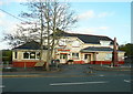
Pontiets library
Library and community hall at Pontiets.
Image: © Alan Hughes
Taken: 16 Mar 2021
0.04 miles
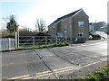
5
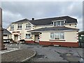
The Welfare Hall Pontiets (Pontyates)
The library is in this building, which is dated 1938
Image: © Humphrey Bolton
Taken: 26 Oct 2016
0.04 miles
6
Footpath beside disused railway line near Pontyates
The last train ran along this section of the Burry Port & Gwendraeth Valley line in 1996.
Image: © Gareth James
Taken: 26 Mar 2022
0.08 miles
7
Redundant level crossing, Pontyates
For a location shot, see http://www.geograph.org.uk/photo/1010634 . This is on the disused Burry Port and Gwendraeth Valley Railway, which ran from near Llanelli to Cwm Mawr. Constructed to transport coal from local mines, it also carried passengers until 1953, and there was a station at Pontyates. The line closed in 1996 when the mines ceased operating. However, a group of enthusiasts has already started restoration work on part of the railway, and hope to be operating trains again in the near future http://www.bpgv.co.uk/ .
Image: © Rose and Trev Clough
Taken: 14 Oct 2008
0.08 miles
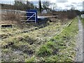
8
Disused level crossing at Pontyates
The last train over this section of the Burry Port & Gwendraeth Valley line ran in 1996.
Image: © Gareth James
Taken: 26 Mar 2022
0.09 miles
9
Disused railway
Remains of the old railway line between Pontiets and Kidwelly.
Image: © Alan Hughes
Taken: 16 Mar 2021
0.09 miles
10
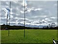
Recreation ground
Pontiets rugby pitch.
Image: © Alan Hughes
Taken: 16 Mar 2021
0.09 miles