IMAGES TAKEN NEAR TO
Ashgrove, LLANELLI, SA15 5LE
Introduction
This page details the photographs taken nearby to Ashgrove, SA15 5LE by members of the Geograph project.
The Geograph project started in 2005 with the aim of publishing, organising and preserving representative images for every square kilometre of Great Britain, Ireland and the Isle of Man.

There are currently over 7.5m images from over14,400 individuals and you can help contribute to the project by visiting https://www.geograph.org.uk
Image Map (Loading...)


Getting Data...Please wait
Leaflet Map data © OpenStreetMap
Images are licensed for reuse under creativecommons.org/licenses/by-sa/2.0
Notes
- Clicking on the map will re-center to the selected point.
- The higher the marker number, the further away the image location is from the centre of the postcode.
Image Listing (19 Images Found)
Images are licensed for reuse under creativecommons.org/licenses/by-sa/2.0
Image
Details
Distance
1
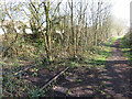
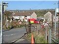
Disused railway in Pontyberem
This section of the Burry Port & Gwendraeth Valley line saw its last train in 1996; its route is now a public footpath.
Image: © Gareth James
Taken: 26 Mar 2022
0.09 miles
2
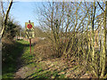
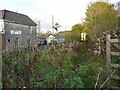
Footpath and disused railway line in Pontyberem
The rails are still in situ in the vegetation on the right, and the board that instructed drivers of trains to stop still stands. However, this section of the Burry Port & Gwendraeth Valley line saw its last train in 1996 and its route is now a public footpath.
Image: © Gareth James
Taken: 26 Mar 2022
0.09 miles
3
Site of former Pontyberem station
This section of the Burry Port & Gwendraeth Valley line saw its last train in 1996; its route is now a public footpath.
Image: © Gareth James
Taken: 26 Mar 2022
0.09 miles
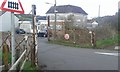
5
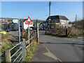
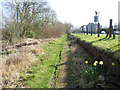
Level crossing in Pontyberem
The disused Burry Port & Gwendraeth Valley line saw its last train in 1996.
Image: © Gareth James
Taken: 26 Mar 2022
0.09 miles
6
Level crossing in Pontyberem
The disused Burry Port & Gwendraeth Valley line saw its last train in 1996.
Image: © Gareth James
Taken: 26 Mar 2022
0.09 miles
7
Level crossing in Pontyberem
The disused Burry Port & Gwendraeth Valley line saw its last train in 1996.
Image: © Gareth James
Taken: 26 Mar 2022
0.09 miles
8
Disused railway line, Pontyberem
This was part of the Burry Port and Gwendraeth Valley Railway, constructed in the 19th century to transport coal down the valley. During the 20th century it also carried passengers, but the service ceased in 1953. Coal freight continued until 1996, when the mines were closed (Railway information was found here - http://www.colonelstephenssociety.co.uk/BPGVLR.html ).
Image: © Rose and Trev Clough
Taken: 15 Oct 2008
0.09 miles
9

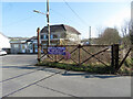
Pontyberem
Cerddwyr yn dilyn llwybr cyhoeddus gyda Chlwb Gweithwyr Pontyberem yn y pellter.
Walkers following a public footpath with Pontyberem Wokingmens Club in the distance.
Image: © Alan Richards
Taken: 31 Aug 2014
0.10 miles
10
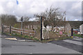
Level Crossing on the Burry Port and Gwendraeth Valley Railway
The last train on the Burry Port and Gwendraeth Valley Railway ran in 1996 when the last coal mine that it served ceased production. Although no longer in use, all the tracks remain in place (albeit now with mature trees growing between them) and strangely, all road signs are maintained at the level crossings despite there being no chance of any trains passing through any more.
Image: © Hywel Williams
Taken: 20 Oct 2019
0.11 miles