IMAGES TAKEN NEAR TO
Pembrey Road, LLANELLI, SA15 3EU
Introduction
This page details the photographs taken nearby to Pembrey Road, SA15 3EU by members of the Geograph project.
The Geograph project started in 2005 with the aim of publishing, organising and preserving representative images for every square kilometre of Great Britain, Ireland and the Isle of Man.

There are currently over 7.5m images from over14,400 individuals and you can help contribute to the project by visiting https://www.geograph.org.uk
Image Map
Images are licensed for reuse under creativecommons.org/licenses/by-sa/2.0
Notes
- Clicking on the map will re-center to the selected point.
- The higher the marker number, the further away the image location is from the centre of the postcode.
Image Listing (27 Images Found)
Images are licensed for reuse under creativecommons.org/licenses/by-sa/2.0
Image
Details
Distance
1
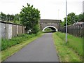
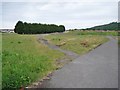
Cycle way under Pembrey Road
This is part of the Swiss Valley Cycle Route which follows a disused railway line that climbs gently from the Millennium Coastal Park into the hills above Llanelli.
Image: © Richard Dorrell
Taken: 17 Jun 2013
0.04 miles
2
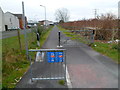
National Cycle Network route 47, Llanelli
A view SSW from the western end of Stradey Park Avenue.
Image: © Jaggery
Taken: 8 Apr 2012
0.04 miles
3
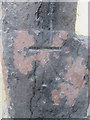
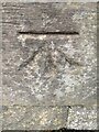
Ordnance Survey Cut Mark
This OS cut mark can be found on the north angle of the White Horse. Now Frankie's Kitchen. It marks a point 6.1935m above mean sea level.
Image: © Adrian Dust
Taken: 15 Jan 2015
0.06 miles
4
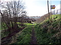
Tuag at lwybr beicio / Towards a cycle path
Llwybr troed yn arwain at Lwybr Beicio 47.
A footpath approaching Cycle Path 47.
Image: © Alan Richards
Taken: 12 Feb 2018
0.06 miles
5
CBM
Cut Benchmark on Sandy Bridge Llanelli
Image: © John Jenkins
Taken: 14 Oct 2021
0.07 miles
6
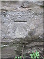
Ordnance Survey Cut Mark
This OS cut mark can be found on the wall to the west of the footpath. It marks a point 5.8308m above mean sea level.
Image: © Adrian Dust
Taken: 15 Jan 2015
0.08 miles
7
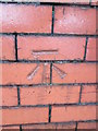
Ordnance Survey Cut Mark
This OS cut mark can be found on the wall of No13 Parkview Terrace. It marks a point 5.9863m above mean sea level.
Image: © Adrian Dust
Taken: 15 Jan 2015
0.11 miles
8
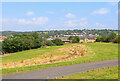
Former rugby club ground
The fenced area is the site of the former stands and pitch of the Llanelli Rugby Club. The club has now moved to new premises, and this site is about to be redeveloped as a housing estate.
Image: © Richard Dorrell
Taken: 17 Jun 2013
0.15 miles
9
Near Sandy Water Park
View across the field towards the hotel.
Image: © Wayland Smith
Taken: 4 Sep 2021
0.16 miles
10
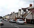
Stradey Park Avenue, Llanelli
Houses on the north side of the road, viewed from the New Road end.
Image: © Jaggery
Taken: 8 Apr 2012
0.16 miles