IMAGES TAKEN NEAR TO
Llwynhendy Road, LLANELLI, SA14 9DP
Introduction
This page details the photographs taken nearby to Llwynhendy Road, SA14 9DP by members of the Geograph project.
The Geograph project started in 2005 with the aim of publishing, organising and preserving representative images for every square kilometre of Great Britain, Ireland and the Isle of Man.

There are currently over 7.5m images from over14,400 individuals and you can help contribute to the project by visiting https://www.geograph.org.uk
Image Map
Images are licensed for reuse under creativecommons.org/licenses/by-sa/2.0
Notes
- Clicking on the map will re-center to the selected point.
- The higher the marker number, the further away the image location is from the centre of the postcode.
Image Listing (63 Images Found)
Images are licensed for reuse under creativecommons.org/licenses/by-sa/2.0
Image
Details
Distance
1
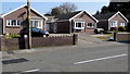
Three bunglaows, Llwynhendy
Viewed across the B4297 Llwynhendy Road. Originally, bungalow was used in English for a lightly-built house, with a veranda and one storey. In current UK usage it is a convenient word for any one-storey dwelling.
Image: © Jaggery
Taken: 17 Mar 2016
0.01 miles
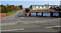
2
Zigzag markings on Llwynhendy Road, Llwynhendy
Marking a Keep Clear zone near the entrance http://www.geograph.org.uk/photo/4905532 to Llwynhendy Children's Club.
The warning sign shows humps for 330 yards.
Image: © Jaggery
Taken: 17 Mar 2016
0.02 miles
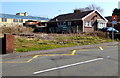
3
Former? business premises, Llwynhendy
In March 2016 there is no name in view to show the current or former use of this building with a metal side door about 3 metres high.
Image: © Jaggery
Taken: 17 Mar 2016
0.03 miles
4
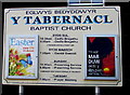
Y Tabernacl information board, Llwynhendy
Facing Llwynhendy Road outside this http://www.geograph.org.uk/photo/4906617 Baptist church.
Image: © Jaggery
Taken: 17 Mar 2016
0.03 miles
5
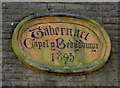
1895 tablet on Tabernacle Baptist Church, Llwynhendy
The inscription showing Tabernacl Capel y Bedyddwyr 1895 is on the pediment here. http://www.geograph.org.uk/photo/4906617
Image: © Jaggery
Taken: 17 Mar 2016
0.03 miles
6
Entrance to Llwynhendy Children's Club
From the B4297 Llwynhendy Road.
Image: © Jaggery
Taken: 17 Mar 2016
0.03 miles
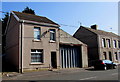
7
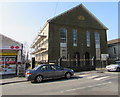
Late Victorian Tabernacle Baptist Church, Llwynhendy
Tabernacle Baptist Church (Eglwys Bedyddwyr y Tabernacl in Welsh) is on the south side of the B4297 Llwynhendy Road. The year 1895 is inscribed on the tablet http://www.geograph.org.uk/photo/4906625 on the pediment.
Image: © Jaggery
Taken: 17 Mar 2016
0.03 miles
8
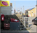
Postbox outside Llwynhendy Stores, Llwynhendy
Located here http://www.geograph.org.uk/photo/4906631 on the right side of the stores.
Image: © Jaggery
Taken: 17 Mar 2016
0.04 miles
9
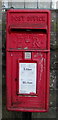
Queen Elizabeth II postbox outside Llwynhendy Stores, Llwynhendy
Located here. http://www.geograph.org.uk/photo/4906644
Image: © Jaggery
Taken: 17 Mar 2016
0.04 miles
10
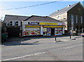
Llwynhendy Stores, Llwynhendy
Premier convenience store and post office at 31 Llwynhendy Road.
Y Tabernacl http://www.geograph.org.uk/photo/4906617 is on the right.
Image: © Jaggery
Taken: 17 Mar 2016
0.04 miles