IMAGES TAKEN NEAR TO
Carmel, LLANELLI, SA14 7UE
Introduction
This page details the photographs taken nearby to SA14 7UE by members of the Geograph project.
The Geograph project started in 2005 with the aim of publishing, organising and preserving representative images for every square kilometre of Great Britain, Ireland and the Isle of Man.

There are currently over 7.5m images from over14,400 individuals and you can help contribute to the project by visiting https://www.geograph.org.uk
Image Map
Images are licensed for reuse under creativecommons.org/licenses/by-sa/2.0
Notes
- Clicking on the map will re-center to the selected point.
- The higher the marker number, the further away the image location is from the centre of the postcode.
Image Listing (4 Images Found)
Images are licensed for reuse under creativecommons.org/licenses/by-sa/2.0
Image
Details
Distance
1
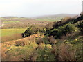
Llwybr ger Danrallt / Path near Danrallt
Llwybr cyhoeddus yn mynd i lawr y waered ger Ffarm Danrallt. Ar adeg ysgrifennu hwn mae'r llwybr wedi'i rwystro.
A public footpath descending the hill near Danrallt Farm (trans. beneath the wooded hill). At the time of writing the path is obstructed.
Image: © Alan Richards
Taken: 5 Feb 2020
0.08 miles
2
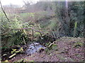
Llwybr Caeffwrn / Caeffwrn Path
Sticil wedi ei hesgeuluso ar lwybr cyhoeddus yn arwain at Ffarm Caeffwrn.
A neglected stile on a public footpath heading towards Caeffwrn Farm (trans. oven / cauldron field).
Image: © Alan Richards
Taken: 5 Feb 2020
0.10 miles
3
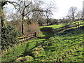
Llwybr Caeffwrn / Caeffwrn Path
Llwybr cyhoeddus yn mynd i gyfeiriad Ffarm Caeffwrn.
A public footpath heading towards Caeffwrn Farm (trans. oven / cauldron field).
Image: © Alan Richards
Taken: 5 Feb 2020
0.18 miles
4
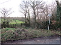
Llwybr Caeffwrn / Caeffwrn Path
Llwybr cyhoeddus yn gadael yr heol ac yn mynd i gyfeiriad Ffarm Caeffwrn.
A public footpath exiting the road and heading in the direction of Caeffrwn Farm (trans. oven / cauldron field).
Image: © Alan Richards
Taken: 5 Feb 2020
0.23 miles