IMAGES TAKEN NEAR TO
Heol Croeserw, PORT TALBOT, SA13 3NU
Introduction
This page details the photographs taken nearby to Heol Croeserw, SA13 3NU by members of the Geograph project.
The Geograph project started in 2005 with the aim of publishing, organising and preserving representative images for every square kilometre of Great Britain, Ireland and the Isle of Man.

There are currently over 7.5m images from over14,400 individuals and you can help contribute to the project by visiting https://www.geograph.org.uk
Image Map
Images are licensed for reuse under creativecommons.org/licenses/by-sa/2.0
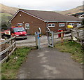
Notes
- Clicking on the map will re-center to the selected point.
- The higher the marker number, the further away the image location is from the centre of the postcode.
Image Listing (59 Images Found)
Images are licensed for reuse under creativecommons.org/licenses/by-sa/2.0
Image
Details
Distance
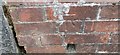
1
Ordnance Survey Rivet
This OS rivet can be found on the step of No3 Heol y fedw. It marks a point 225.397m above mean sea level.
Image: © Adrian Dust
Taken: 24 Nov 2020
0.05 miles
2
Steps up to Coronation Terrace Croeserw from Cymmer
From the south side of the A4107, at the eastern edge of Alder Terrace, Cymmer.
Image: © Jaggery
Taken: 25 Feb 2015
0.07 miles
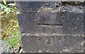
3
Ordnance Survey Cut Mark
This OS cut mark can be found on the wall between Nos9 & 10 Alder Terrace. It marks a point 196.892m above mean sea level.
Image: © Adrian Dust
Taken: 29 Apr 2017
0.07 miles
4
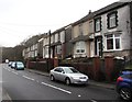
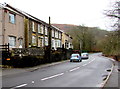
Alder Terrace, Cymmer
Houses on the south side of the A4107.
Image: © Jaggery
Taken: 25 Feb 2015
0.07 miles
5
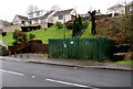
Alder Terrace gas installation, Cymmer
Wales & West Utilities gas installation viewed across the A4107.
An EX inside a yellow triangular notice warns of a potentially explosive atmosphere. No smoking.
Image: © Jaggery
Taken: 25 Feb 2015
0.07 miles
6
A4107 passes Alder Terrace, Cymmer
Looking west towards the centre of the village.
Image: © Jaggery
Taken: 25 Feb 2015
0.07 miles
7
Ordnance Survey Cut Mark
This OS cut mark can be found on the wall of No2 Alder Terrace. It marks a point 196.752m above mean sea level.
Image: © Adrian Dust
Taken: 29 Apr 2017
0.08 miles
8
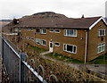
West side of Arwelfa House, Croeserw
Residential care home at 35 Eastern Avenue.
Image: © Jaggery
Taken: 18 Feb 2015
0.08 miles
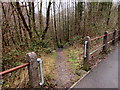
9
Cycle route from Cymmer reaches Croeserw
Looking east along National Cycle Network route 885.
Image: © Jaggery
Taken: 18 Feb 2015
0.09 miles
10
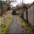
Path down to the valley of the Afon Afan, Cymmer
River valley path from the A4107.
Image: © Jaggery
Taken: 25 Feb 2015
0.09 miles