IMAGES TAKEN NEAR TO
Brytwn Road, PORT TALBOT, SA13 3EP
Introduction
This page details the photographs taken nearby to Brytwn Road, SA13 3EP by members of the Geograph project.
The Geograph project started in 2005 with the aim of publishing, organising and preserving representative images for every square kilometre of Great Britain, Ireland and the Isle of Man.

There are currently over 7.5m images from over14,400 individuals and you can help contribute to the project by visiting https://www.geograph.org.uk
Image Map
Images are licensed for reuse under creativecommons.org/licenses/by-sa/2.0
Notes
- Clicking on the map will re-center to the selected point.
- The higher the marker number, the further away the image location is from the centre of the postcode.
Image Listing (77 Images Found)
Images are licensed for reuse under creativecommons.org/licenses/by-sa/2.0
Image
Details
Distance
1
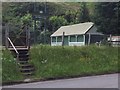
Cymmer Bowling Club
Entrance to the bowling green and club at Cymmer.
Image: © Alan Hughes
Taken: 3 Jun 2017
0.04 miles
2
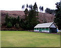
Bowling green and pavilion, Cymmer
Cymmer Welfare Bowling Green, http://www.geograph.org.uk/photo/4356970 set slightly above the A4107 at the western edge of Cymmer.
Image: © Jaggery
Taken: 18 Feb 2015
0.04 miles
3
Cymmer Welfare Bowling Green
Set slightly above the A4107 at the western edge of Cymmer.
Image: © Jaggery
Taken: 18 Feb 2015
0.04 miles
4
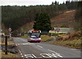
Port Talbot bus leaving Cymmer
Viewed across the A4107 Brytwn Road. A First bus is on route 23 to Port Talbot.
Image: © Jaggery
Taken: 18 Feb 2015
0.05 miles
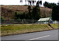
5
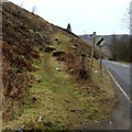
Steep bridleway from Cymmer to Afan Argoed
The bridleway ascends from the A4107. The bridleway sign shows 5 km to Afan Argoed. There is no distance shown in miles. A bridleway is a route for horse riders and walkers, but not for vehicles.
Image: © Jaggery
Taken: 18 Feb 2015
0.05 miles
6
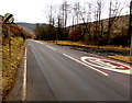
End of the 30 zone along the A4107 west of Cymmer
From 30mph to the National Speed Limit on the road to Port Talbot.
Image: © Jaggery
Taken: 18 Feb 2015
0.06 miles
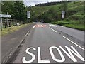
7
End of the 20 zone at the western edge of Cymmer
The speed limit on the A4107 increases from 20mph (near a school) to 30mph ahead.
Image: © Jaggery
Taken: 18 Feb 2015
0.06 miles
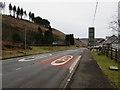
8
Traffic Control Measures
Signs and speed humps help to calm traffic on entry into the village of Cymmer.
Image: © Alan Hughes
Taken: 3 Jun 2017
0.06 miles
9
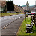
Roadside bench near the western boundary of Cymmer
Alongside the A4107. The back of the Cymmer boundary sign http://www.geograph.org.uk/photo/4353092 is a few metres from the bench.
Image: © Jaggery
Taken: 18 Feb 2015
0.06 miles
10
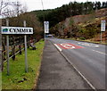
Western boundary of Cymmer
The A4107 reaches Cymmer, a village in Neath Port Talbot county borough.
Image: © Jaggery
Taken: 18 Feb 2015
0.06 miles